Sierra del Lacandón National Park, Maya Biosphere Reserve, Guatemala
Laura Geiger, Felix Cybulla, & Pierre L. Ibisch
General setting
In Guatemala, the early version of the methodology was applied in a first workshop on March 2011. The workshop was part of the Risk Management project component within a Forest conservation project implemented by the German NGO “OroVerde” and the Guatemalan NGO “Defensores de la Naturaleza” (Defensores)[1].
Box 1: The National Park Sierra del Lacandón
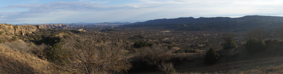
“Sierra del Lacandón National Park is located in north-western Guatemala in the province of Petén and shares borders in the north and west with Mexico; the Usumacinta river provides a natural western border between the two countries. The park was created in 1990 and is Guatemala’s second largest national park with 202,865 hectares. It is characterised by a high biodiversity - it has more than 200 tree species per hectare and 31 mammal species and 213 bird species have been registered for the entire park area. Its uneven topography and high annual precipitation create a humid forest mosaic, with lakes, patches of wetlands and savannah riparian forests. The area’s geology is karstic with hills formed by folding limestone and plains (APESA 1993).
Around 20,000 habitants live in the park. The communities inside the park settled there before the park was formally created. The population consists of 73% mestizo or Hispanicised settlers and 27% indigenous inhabitants (Defensores & CONAP 2006). The communities have historic tenure rights and can sign cooperation agreements with the protected area authority to regulate their presence in the park. Three of these agreements have been signed so far (OroVerde 2012). The main income sources for these communities are cattle ranching (54% of income), agriculture (26%), and use of forest products (8.5%) (Suter & López-Carr 2010). The park is divided into three zones: 1) the core zone – an area strictly dedicated to conserving biophysical characteristics in pristine condition (58% of park area), 2) regeneration zone (13%), and 3) zone of special use – an area designated for the sustainable use of the natural resources (29 %) (Defensores & CONAP 2006). The latter is the most populated area of the park. It is dominated by an agricultural landscape, which is partially severely degraded.
The park is co-managed by the national NGO Defensores de la Naturaleza, which has approximately 33 staff members for the Lacandón National Park that includes scientists, rangers, guards and administrative personnel. The CONAP park office is located 3 hours outside the park, and there are less than 5 overnight field posts in the park. Defensores de la Naturaleza also manages other protected areas in the country, responsible for roughly 5% of all Guatemalan territory.
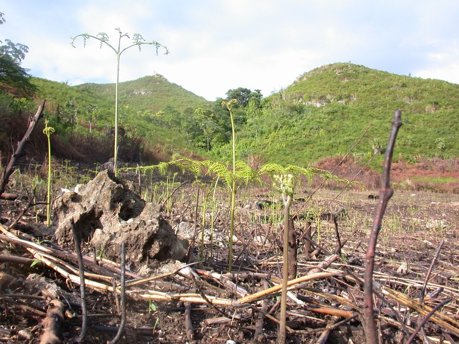
Forest fires due to agricultural and cattle ranching activities are one of the threats against the park. Deforestation for the purpose of creating agricultural and grazing land – as well as from illegal activities within the park - result in a mean annual deforestation rate of 1,200 ha (to date around 50% of the original forest cover has been lost or highly fragmented). This, in turn, results in soil degradation and erosion of the existing karstic soil. The clearing of forest areas was fuelled by the internal population growth and the increasing demand for resources by the households (by average 8 children/family) in the area. A population explosion is expected in the near future (72% of population is under 25 years old, Defensores & CONAP 2006) and will rapidly increase the land conversion problem.
Additionally, climate change is a threat of increasing relevance for the area (Edmeades 2009, IPCC 2007): precipitation reductions and droughts are thought to enhance forest fires and thus lead to a reduction of biodiversity and biomass. The lack of (adequate) personnel for patrolling, maintenance, and guiding projects becomes yet another problematic factor (ParksWatch 2003)”. (Extract from Geiger et.al 2011)
Workshops and work flow
Consultants guided the planning team through the methodological steps of MARISCO in the first 3-day workshop. In order to conduct a complete situation analysis of the area, the scope was defined, as well as the conservation objects, their direct threats and contributing factors. The team analysed and compared former strategies named in the previous management plan and the upcoming plan. Strategies were also reformulated and developed in areas that had none. Past and present strategies were then discussed and evaluated.
A follow-up discussion was scheduled and the results were reprocessed, digitalised, completed, cleared of redundancies and sent out for revision to key team members in Guatemala. Prior to the conduct of the second workshop, a draft of the Management Plan 2011-2015 was analysed and reviewed using the comments and findings from the first workshop. The draft’s shortcomings and inconsistencies were also identified. The reviews pointed out and addressed the lack of focus on direct threats during the strategy development phase, the lack of proper priority setting for strategies and activities, and thorough evaluation of threats by pre-defined indicators.
[1] The aim of the “Lacandón - Forests for Life” project is to significantly reduce the deforestation rate and to conserve biodiversity with the possibility to apply for a REDD project (Reducing Emissions from Deforestation and Forest Degradation) by 2014. Eberswalde University for Sustainable Development was responsible for the design and a proposal for implementing the risk management approach. This cooperation framework between all partners is funded by the European Union (EU), and the International Climate Initiative of the German Federal Ministry for the Environment, Nature Conservation, Building and Nuclear Safety (BMUB-IKI). www.bosques-lacandon.org GIZ funded additional coaching support in a second workshop in October 2012.

Based on the results of these discussions, the situation analysis from the March 2011 workshop was revised to include factor evaluations in order to track changes concerning their impacts.
Taking into account the more than 70 strategies from the upcoming management plan, a second round of strategy reduction and reformulation was necessary. Based on this, the expected results related to each strategy where formulated in a time sequence, the so-called result chains or webs. They form the base to identify and refine necessary activities in order to meet with pre-defined conservation objectives and goals.
Out of the 15-20 participants that attended each workshop the majority was made up of staff members from the Defensores (including rangers, scientists and the head of the management) as well as members of the government park authority. One university scientist also participated. Other stakeholders such as community leaders and members, big-scale farmers from the park as well as other organisations, were not in the workshops.
Results
From the two workshops a conceptual model that identified the stresses, threats and contributing factors was elaborated. The original scope was redefined after the team realised that the Mexican territory has a major relevance to the national park, as it facilitates illegal traffic and infrastructure pressures and has connectivity potential.
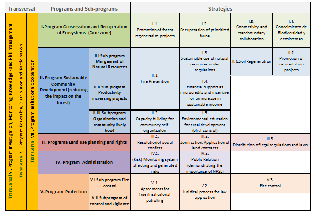
All factors were evaluated according to the MARISCO criteria. The existing strategies were reformulated and evaluated by strategy categories and finally revised again by the team. The team also produced two result webs in order to prove their strategy assumptions for the two key strategies Fire prevention and Territorial order. Three more result chains were constructed in the follow–up process with key team members.
The results of the workshop led to new management insights and implications for the project such as:
Strategy (Activities) / objective development and monitoring based on threat priorities
The necessity to link strategies directly to the threats is an important methodological requirement. Through several discussions it became clear that it was easy to lose focus from the agreed objectives, especially if the project has several partners that have different norms and priorities. For instance, the objective Increasing the income for communities has the ultimate goal to reduce deforestation in the park, therefore the strategies, activities and the monitoring have to reflect this in their formulation e.g. Increasing the income for communities in order to reduce deforestation. That was not always clear for the team.
Another example is the strategy Demarcation with fire-breaks, which bears risks related to improved access and even facilitation of fire expansion and will have to be analysed in a more detailed way.
The preparation period and the workshop helped reduce the number of strategies from 77 to less than 18 strategies. It was obvious that the team’s absence of formal distinctions between strategies and activities and the lack of consideration of threats while developing the strategies led to huge number of unclear strategies in the previous process.
The result-webs provided a structure for setting the activities in a frequency and time line order, which helped the team to avoid priority setting of activities while ignoring their timeline sequences. For example, in the former management plan the activity B had a higher priority than activity A even though they were time related and A had to be accomplished before B. By using the results webs another benefit was to identify risks along the assumed outputs from a strategy. Being aware of possible scenarios is essential for effective proactive planning.
The importance of the future factor analysis
In the analysis of future factors, population growth, invasions, and climate change were seen as highly critical as they have the potential to impact the demand for resource and less available fertile land, which would lead to massive rapid deforestation and change in biodiversity. The unclear development of drug activities and social conflicts and their potential risk impacts for the future were also discussed and led to more awareness within the team.
System inter-linkages and synergy potentials of strategies and activities
As part of the systemic situation analysis four reinforcing feedback-loops were identified (e.g. poor soils lead to demand for land named as Land use change which causes deforestation which leads to soil degradation = the loop is closed and starts again). It was highly helpful for the team to understand their dynamics and exponential growth in particular and the necessity to cut-off these loops with a qualified strategy.
The inter-linkages between the strategies became clear especially by identifying key activities with high synergy potential such as Promotion of sustainable agroforestry systems which is part of the following strategies: Promotion for reforestation, Financing alternative sustainable economies, Prevention of forest fires and Promotion for soil regeneration.
Risk management
Risk analysis has to be a transversal approach in the management in order to see the overlaps and the intersections of various factors. In the workshop a transversal strategy VI. for Investigation, Knowledge, Monitoring and Risk Management was developed.
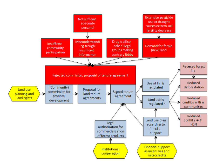
For the planning team it was an extra step to distinguish between affecting risks, which harm the project but also identify generated risks by the park management itself, which can imperil the project in the long (re-bouncing risk). For example, creating social conflicts through the project management itself can bounce back and influence further cooperation with communities in the park; in the worst case it can hinder the signature of land tenure agreements. It became clear for the team that a risk analysis should not only be applied in the first stage of the project cycle in the situation analysis, but also in the subsequent steps for each strategy and activities.
Outcomes and conclusions
MARISCO helped to identify aspects of risk management needs on various levels such as on socio-economical and biophysical level, but also on the institutional/ administrative level, which concerns the knowledge management in the organisation itself. In the Sierra del Lacandón National Park, the MARISCO methodology was used to integrate an ecosystem-based adaptation strategy into the management plan of the park.
Due to the fact that the methodology and workshops have a very participatory and visually oriented design, the team was able to understand the complexity of the area and the interlinkages of the different systems, as well as the risks and the potential synergies of the various strategies. Because the approach involves various stakeholders including team members from different sectors the workshops led to an increased understanding of team member’s work and different perspective of the situation.
It became clear that a ‘culture of mistake-friendliness’ has to be communicated to all participants – from the donors to the local stakeholders in order to provide an atmosphere of fruitful learning. This led finally to an increased awareness of errors, uncertainties and risks.
The two workshops, conducted within 1½ years, were very helpful for the team because it allowed them to review the entire conceptual model including targets, threats and strategies as needed. The results from the workshops will be used for the database that will be fed into new smartphone application tested in this pilot project.
To ensure a very effective implementation of the workshop results into a management plan, close methodological guidance over a long period of time by consultants is necessary. Workshops alone cannot guarantee the implementation of the MARISCO approach.
Nevertheless, the experience showed that apart from a generous time frame that would allow reviews of the plan, other conditions have to be in place for a successful implementation of the method. The organization has to have the capacity not just to implement the methodology but to provide logistical support. It is necessary that the team has established documentation procedures in tracking changes, monitoring failure or success of strategies, accessible and transparent storage for scientific knowledge and map materials in order to easily share and assess their knowledge.
References
APESA 1993, Evaluación Ecologia Rápida de la Reserva de la Biosfera Maya. Guatemala, Guatemala", APESA, TNC,PBM - USAID
MARISCO was developed by

MARISCO development and website were supported by
assisted by
© Centre for Econics and Ecosystem Management e.V. - Eberswalde University for Sustainable Development