MARISCO at a lakescape: Student course on Lake Shkodër, Albania
Lena Strixner, Peter R. Hobson & Pierre L. Ibisch
General setting
In January 2013, a small team of facilitators from the Centre of Econics and Ecosystem Management delivered a study course on MARISCO to a group of 25 students from the Agricultural University of Tirana in Shkodër, Albania[1]. The main aim of the week-long project was to enable students to demonstrate applied skills in the use of MARISCO as an appropriate method in adaptive conservation management planning. Most of the participants were students from natural or environmental sciences. The participants were split into four working groups and each team was given the same case study, which was Lake Shkodër.
[1] The study course, titled “Adaptive Conservation Site Management under Global Change“ was funded by the German Federal Foreign Agency through the German Academic Exchange Service (DAAD). We would like to thank Mark Rupa for organising brilliant insights into the case study region by meeting local experts and visiting highly interesting places as well as for his powerful logistical support before and during the workshop. Many thanks also to the workshop participants for their big enthusiasm and very warm welcome to their country. We would like to thank the DAAD for funding this activity and thus making possible a wonderful exchange and a starting cooperation. Many thanks we want to give also to the Shkodër University for supporting us with its facilities, especially with a great room for the workshop.
Box 1: Lake Shkodër
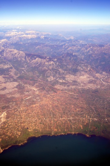
Lake Shkodër - also called Lake Scutari and Lake Skadar is the largest lake in the Balkan Peninsula with an area varying between 353 km² and 500 km², depending on the season. The lake is dissected by the national borders between Albania and Montenegro. Within the borders of Montenegro the lake is designated a National Park (IUCN-category II), whilst in Albania it is under the protection status of Managed Conservation Area (IUCN-category IV) with a small core zone designated under strict protection. The lake is fed by several rivers that have their headwaters in the surrounding mountains. Approximately 25% of the water feeding the lake is from the numerous ground springs in the Karst bedrock under the lake and is of very high quality. However, there are serious concerns about the level of pollution feeding into the main rivers from the large towns and industrial hubs bordering the lake and the mouth of the larger rivers, in particular the untreated waste water. Along the east and northern side of the lake are a series of large flood plains, which have been traditionally farmed over the centuries. Complex networks of drainage channels help regulate the unpredictable seasonal flood waters but in most years large tracts of farmland succumb to winter flooding. During the drier summer season the flood meadows are grazed by cattle as they have been for many centuries. The decrease in fish stocks caused by over-fishing and pollution has impacted on the fishing industry and forced fishermen to seek work elsewhere. Few remaining small villages on the coast of the lake and on the mouth of the river Buna, the main outlet from Lake Shkodër on the south side, still depend on fishing for their livelihood. . Approximately 1 km from its source the River Buna is joined by the much larger Drini River that has its origins in the extensive mountainous area to the east of the lake. . The upper reaches of the Drini have been dammed in several places to harness the water for electricity. However, the combination of damming and unusually high precipitation levels in the region require regular control measures to be taken involving the release of storm water. The effect of this action is to cause sporadic ‘flushing’ of the river system. During these events substantial quantities of river bed material is eroded and redeposited downstream, just before and after the confluence with the Buna. The gradual build up in sediment at the confluence is changing the structure and dynamics of both rivers, and causing significant backwash into the lake. Adding to this problem is the excess water run-off from the hills surrounding the lake brought on by the overgrazing of vegetation that has reduced much of the plant cover to patchy stubble.
The complex interactions between natural processes and human activity are complicated by larger forces of change linked to global warming. Apart from problems of unpredictable flooding, drier summers have encouraged more forest and scrub fires. Sources: APAWA & CETI 2007; own observations and interviews with local stakeholders.
Workshops and work flow
Following a brief ‘ice-breaker’ session and an introduction to the topic and programme the participants were given three questions to discuss during the plenary, which were:
- Which of the main natural attributes in your region of Albania do you feel are most important and in need of conservation action?
- What is your personal interpretation and understanding of nature conservation?
- Who in Albania is responsible for carrying out nature conservation?
The workshop included an introduction to the terms/concepts used in MARISCO, an overview of international and European nature conservation as well as information about the IUCN activities related to transboundary nature conservation in South-East-Europe.
The case study was introduced by presenting the detailed findings of an Ecosystem Diagnostics Analysis (EDA), which included the results of a spatial assessment using both Google Earth images and cartographic evidence supported by published information on environmental and ecological conditions. Specific targeted sites identified in the spatial assessment were visited in the field to add detail to the observations. A number of local folk working in construction and in fishing were also interviewed to establish an on-ground perspective of some of the problems encountered in the landscape.
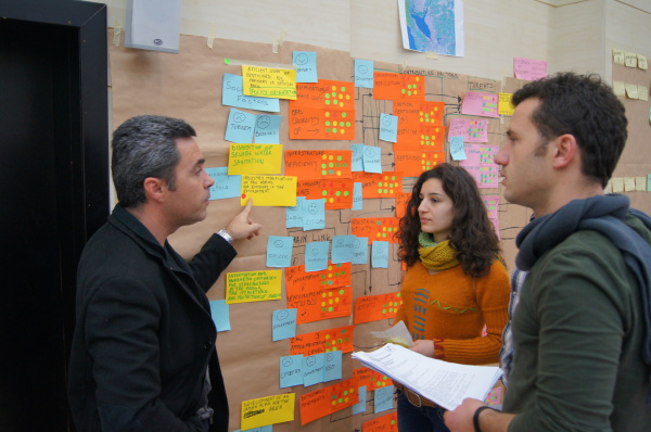
On the following day, the MARISCO workshop was launched with an introduction to the methodology followed by short introductions, group work sessions and peer reviews for each of the steps 1-15 in the planning process. As stated before, the main objective of the exercise was to provide students with a good working knowledge of MARISCO rather than produce final strategic solutions to the socio-environmental problems identified during the exercise. The key elements of the process included the identification of the primary drivers of change and the projected threats arising from these problems in the future. Based on this analysis strategies were identified and results chains/webs were developed. Towards the end of the week the formulation of goals, activities and objectives as well as the rating of strategies were carried out by each of the four groups.
Each stage of the planning process was covered by an introduction lecture from the team leader as well as appropriate interventions by coaches when it was deemed necessary to explain some of the complicated steps.
Results
The student groups identified a range of important biodiversity conservation objects including forests, rivers, lakes, lagoons as well as more specific features such as red book and endemic species and medicinal plants.
In the geographical scoping exercise it was apparent that most of the participants focused on the immediate area defined by both the physical boundaries of the lake or the area of the lake within the national border of Albania. One of the groups proposed a bigger transboundary area, taking into account both the lake and mountain systems. After a brief feedback session amongst peers all four groups modified their geographical scope to include the surrounding landscape and main adjacent functional ecosystems such as forests.
The tendency to take a site-specific perspective to environmental or ecological investigations in preference to a broader landscape approach is not peculiar to students, but is also common amongst conservation practitioners. It exposes the underlying scientific principles and concepts used in academia and the sector to inform enquiry and decision-making. Conventional scientific reductionism favours site or object-specific investigation and avoids a systems approach for fear of losing directly observable patterns. It is widely understood amongst scientists that levels of uncertainty and complexity increase as the scale of resolution gets larger and this can lead to difficulties and errors in interpreting patterns. It was apparent in this exercise that students were unaccustomed to working to much larger scales of resolution other than the immediate target area or feature. Concepts of landscape ecology and large ecosystem-based dynamics and patterns appear not to be addressed in higher education environmental studies.
After the scoping exercise each of the four groups were tasked with producing a detailed conceptual model (sometimes referred to as a situation analysis). Participants were encouraged where possible to order biodiversity objects into nested groups. One of the groups used the term lakescape to describe the collective complex network of lake habitats, the river catchment, marshland, forested areas and agricultural land within a loosely defined buffer zone of the Lake. They also identified relevant ecosystem goods and services like commercial fish species and timber.
During the process of identifying conservation objects many of the participants put stronger emphasis on those objects and attributes that had direct use value rather than intrinsic biodiversity interests. For instance, commercial fish stocks, forests and ‘wild sage sites’ were prioritised over other biodiversity interests such as high diversity of bird species and locally important plants. Working with the conservation objects the students constructed a list of ecosystem services such as ‘protection from natural hazards’, ‘better health conditions’, and ‘recreational pleasure’. It is difficult to establish any single explanation for the choices made other than to suggest that it reflects on the immediate needs of the local communities from the region and country, and the sense of urgency felt in the young educated class to seek opportunities to secure the socio-economic wellbeing of the community wherever possible. At the moment, large sections of society in the region continue to rely heavily on the direct benefits of ecosystems for their livelihood.
In a general scenario exercise large-scale drivers of environmental threats and risks were categorised according to global, European and Albanian influences. The purpose of asking the groups to consider the main trends and drivers of change at a larger scale was to make them aware of the nature of complex systems and also to get them to appreciate the interdependency of systems across scales. A good example from the four groups was the issue of global population growth and how this influenced more local patterns of population movement to bigger cities as well as the increasingly globalised supply and demand for food. Some of the participants were demonstrating a clear understanding of the relationship between global trends and local factors such as “free elections, corruption, civil movements, living standards, climate change, and changes to the economic model”. Using the MARISCO ranking system key factors were drawn up in order to develop a list of strategic objectives that would reduce the potential risks from threats and help safeguard the conservation objects. The kinds of strategies developed were to do with training protected area staff; improve their level of expertise; to use the local and national education systems to promote the benefits derived from a “green” and healthy environment; to encourage transboundary cooperation for more environmental friendly industry; to instigate the development of an urban plan for the area and the construction of sewage water sanitation.
Outcomes and conclusions
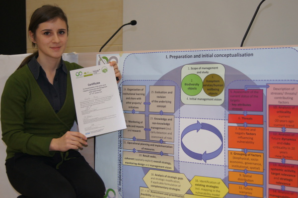
The main conclusion that can be drawn from carrying out this exercise is that the structure and style of delivery used in MARISCO provides a valuable learning platform for both students and practitioners wishing to develop skills in adaptive conservation planning. It is believed that the EDA component of the method gives the participants a robust practical understanding of the environment and landscape that improves their capability of making informed judgments about the situation under review. In the feedback from the students the element of EDA that included local community interviews was considered to especially valuable in helping to understand some of the more important causes of environmental problems. The findings of the MARISCO exercise were presented to nature conservation practitioners from the local protected area administration for review and comments.
Participants felt that the experiential style and method of learning contributed significantly to their academic and sector-related skills development. The majority of the students believed the course contributed significantly to their knowledge of adaptive conservation site management. The general view expressed in the feedback was that the course contributed significantly to the development of employability skills.
The best of the course “was to learn more about adaptive management. We learn how to work in group and the methodology was excellent”
“The methodology used was among the best that I know so far in connection with the development of strategies.”
Feedback about the problems encountered affecting the learning experience were related to language problems and understanding of new technical terms and concepts. As it is a complicated process there is a need to keep the language simple and to structure the delivery in a way that has broad appeal and avoids technical or linguistic convolution.
Reference
Association for Protection of Aquatic Wildlife of Albania (APAWA) and the Center for Ecotoxicological Research of Montenegro (CETI), 2007. [pdf] The Strategic Action Plan (SAP) for Skadar/Shkodra Lake Albania & Montenegro. Ministry of Tourism and Environment of Montenegro (MoTE) and Ministry of Environment, Forests and Water Administration of Albania (MEFWA). Available at: http://www.gov.me/files/1248091290.pdf [Accessed 20 July 20 2014].


