Transboundary management at a small scale: The municipal protected areas of Siete Iglesias and Tinajillas-Río Gualaceño in Ecuador
Axel Schick, Nadia Manasfi, Christoph Nowicki, Miriam Factos & Pierre L. Ibisch.
General setting
GESOREN (‘Sustainable management of natural resources') was a programme between the Government of Ecuador and German development cooperation (GIZ). Between 2004 and 2013, the programme had the objective to support poor rural population in implementing strategies and methods that allow them to manage their natural resources
sustainably and to increase their income. In collaboration with the Ministry
of the Environment, GESOREN assisted various local governments in the province of Morona Santiago in southern Ecuador in the establishment of two municipal protected areas[1].
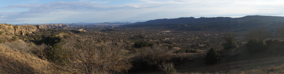
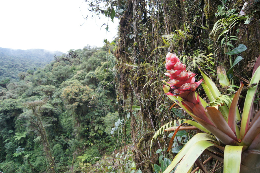
The two municipal protected areas are located in the province of Morona Santiago, on the eastern slopes of the Andes in the south of Ecuador. The region is dominated by livestock farming and to a lower degree by agriculture, which is mainly for subsistence. Small scale mining activity can be found along the rivers within the areas, though future regulation of this activity is planned. The population density is still very low. According to national statistics most of the population is considered to be poor (1).
[1] In an effort to strengthen existing management plans of the municipal protected areas, it was decided to analyse the areas' vulnerability and to consider potential risks such as climate change more explicitly in the management plans. GESOREN joined forces with the project 'Support to the National System of Protected Areas' (financed by German Financial Cooperation KfW and executed by GOPA) in order to contract the Eberswalde University for Sustainable Development who carried out the analysis.
Box 1: Área Ecológica de Conservación Municipal Siete Iglesias (AECMSI)
The Área Ecológica de Conservación Municipal Siete Iglesias (AECMSI) was established in February 2009 as the first protected area of the country that was not managed by the central government (2). It is located in the western part of the canton San Juan Bosco in the parishes of San Juan Bosco and Pan de Azúcar[1].
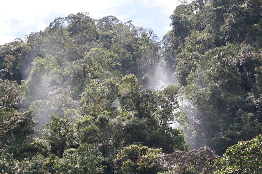
The protected area has an area of 16,050 ha, covering the Cordillera Siete Iglesias and the Pan de Azúcar mountain, both known for their high biodiversity, scenic beauty and provision of important ecosystem services for the region. Starting at an elevation of 1,140 m, the protected area reaches its highest point at 3,840 m, thus covering a wide range of altitudinal levels (3). No roads cross the protected area, but some minor tracks lead into the mountain forests at the lower altitudinal levels. Most of the protected area is covered with primary forest, though settlers have cleared some areas in the past and converted them into pastures.
The Área Ecológica de Conservación Municipal Tinajillas–Río Gualaceño (ACM-TRG) is located adjacent to the ACEMSI. Most of its 33,080 ha belong to the province of Morona Santiago, with a minor part (> 1 %) belonging to the province of Azuay (4).
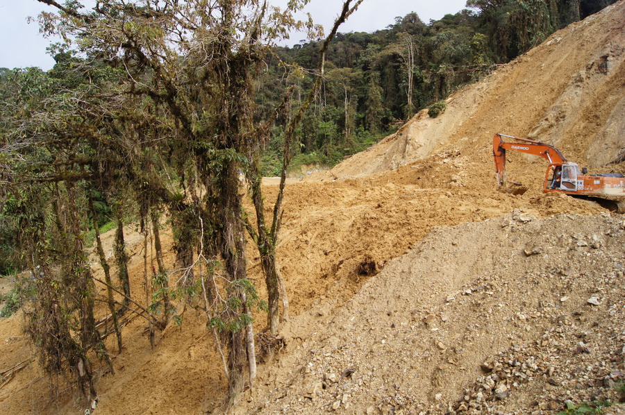
The Tinajillas-Río Gualaceño proteced area is divided by a 32 km long road that was built around 40 years ago to connect the towns of Limón Indanza and Gualaceño. Small-scale farmers have settled along the road and have built small roads and tracks that lead to the interior of the protected area. The altitudinal range is similar to that of the neighbouring protected area, though starting slightly higher at an elevation of 1,427 m and extending up to 3,880 m.
Both municipal protected areas are located in the drainage basins of the Zamora and Santiago Rivers and share the same climatic and geographic conditions. Due to their steep slopes, the areas face a high probability of erosion. Around 10 % of the area is considered geologically unstable and according to the land-use plan it should only be used to protect the soil with natural vegetation.
The average annual precipitation is around 2,500 mm (6). The mean temperature varies along the broad altitudinal gradient, leading to a variety of vegetation types, life zones and habitats. Basically three different habitats can be distinguished along the altitudinal gradient: Tropical mountain rainforests, cloud rainforests and páramo (highland moor ecosystem) in ascending order (7).
Over 106 bird species have been registered in the municipal protected areas and their buffer zones, belonging to 33 families, mainly Thraupidae (Tangaras), Tyranidae (Flycatchers) and Trochilidae (Hummingbirds). The endangered Golden-plumed Parakeet (Leptosittaca branickii) can also be found in the protected areas, as well as the Masked Mountain Tanager (Buthraupis wetmorei) and the Solitary Eagle (Harpyhaliaetus solitarius), both considered vulnerable (8). The protected areas are also home to other endangered species like the Mountain Tapir (Tapirus pinchaque), the Spectacled Bear (Tremarctos ornatus) and the Puma or Mountain Cat (Puma concolor).
[1] The buffer zone overlaps at least partially with eight cantons, four belonging to the Azuay province (Sigsig, El Pan, Chordeleg and Gualaceo) and four belonging to Morona Santiago (Gualaquiza, Limon Indanza, San Juan Bosco and Santiago de Mendez).
Workshops and work flow
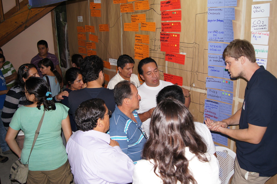
Prior to the first workshop in March 2013, the consultants undertook a short Ecosystem Diagnostics Analysis (EDA) together with the managers of the local protected areas and a GESOREN advisor. During the workshop, impressions were shared and discussed with the participants.
On 7-8th March 2013 in the town of San Juan Bosco, around 30 participants from both municipal protected areas, the Ministry for Environment and the German Development Cooperation (GIZ, KfW/GOPA) conducted a vulnerability analysis, covering both protected areas and their buffer zones. Applying the MARISCO methodology, participants developed a complex situation analysis as a critical part of the vulnerability assessment. The work involved the discussion of technical presentations in plenary sessions as well as a participatory analysis of two protected areas in separate working groups. The results of the first workshop were documented and presented in an intermediate report.
The second workshop was held in the town of Limón Indanza on 6-7th May 2013. In addition to the participants of the first workshop, a representative of the neighbouring canton of Gualaquiza joined the group. At the time, Gualaquiza was in the process of establishing its own municipal protected area and it was thought that its representative could benefit from the rich discussions that are part of the MARISCO workshops. Between the first and the second workshop, the consultants had revised and complemented the situation analysis developed during the first workshop. As such, at the beginning of the second workshop, participants validated the revised situation analysis and proceeded to the evaluation of strategies of the existing management plan. Strategic gaps were identified and new strategies were formulated to target existing and future threats to biodiversity. Due to a limited amount of time available, the new strategies were not evaluated.
After the second workshop, the results and major outcomes were presented in the town halls of Limón Indanza and San Juan Bosco, as well as during a feedback session with members of the Ministry for Environment, German Development Cooperation (GIZ, KfW/GOPA), the municipality of Limón Indanza as well as several NGOs in Quito. Later on, the results of both workshops were presented in a final report (9).
Results
Early on the participants realised that the two protected areas are highly connected and threatened not only by processes within, but also by those originating in the surrounding area. As a result, it was agreed that the analysis should consider the vulnerability not only in the two protected areas, but also in the buffer area and an even broader area of influence, thus covering the mountain range and its eastern slopes, all the way down to the towns of San Juan Bosco and Limón Indanza.
The effects of climate change on ecosystems, as well as its consequences for agriculture and especially livestock farming were evaluated and considered to be of great importance. The loss of social cohesion within and among the communities was also of great concern.
At the beginning, the representatives of the two municipal protected areas evaluated their existing strategies separately (i.e. per area), but soon identified similarities and problems in common between the adjacent protected areas. In order to address the identified transboundary threats, the approach was changed to pursue common strategies. A list of complementary and reformulated strategies was prepared, but due to the limited amount of time these strategies could not be evaluated. Nevertheless, these identified strategies could serve as an important input for a future update of the management plans.
The workshops helped participants to improve their knowledge about climate change and the concepts of vulnerability. The potential future risks of climatic and socioeconomic changes in the region were discussed. Additionally, the workshops served as a platform for the presentation and communication of the practitioners of the two protected areas, the mutual learning process and the discussion of a possible trans-municipal management scheme. A group dinner allowed participants to break the ice further, to get to know each other and to establish a relationship on a non-work related basis.
Though the main purpose of the workshops was to strengthen the capacities of the local conservation practitioners and to analyse the vulnerability of each protected area, it also served as a starting point for much more intensified cooperation and coordination among the two municipal protected areas, grounded on a shared understanding of the areas’ challenges.
The concepts of risk and vulnerability, as well as the integrative approach to deal with complexity were new to most of the participants, but they got accustomed to them very quickly. The workshops fulfilled their goal to broaden the knowledge of the local conservation practitioners and demonstrated that satisfying results can be obtained, even if the understanding of the participants of ecological and complex theory is limited.
Outcomes and conclusions
According to the analysis, the ecosystems of the region are generally still in very good condition, though climate change may have major impacts, not only for the ecosystems but also for the local population. The main economic activity of the region is livestock farming, implementing a special technique where the cattle is not allowed to freely range in the pastures, but is tied to a short rope, allowing the animal to graze only within the close vicinity (so-called ganaderia al sogeo). Due to high humidity and precipitation, the pastures provide enough water for the cattle to guarantee a sufficient hydration. With an increasing risk of droughts and higher temperatures, this system is highly vulnerable. The communities living along the rivers in the valley are also vulnerable to extreme events. The deforestation of the mountain forests reduces their capacity to retain water and increases the risk of floods during extreme rainfall. Given the trends of the development of the region, the need for the services provided by the ecosystems, especially regulating services, will increase in the future, as will the pressure on them.
The good condition of the ecosystems and the strong social cohesion of the communities might explain why the participants had some difficulties to imagine future changes within the region. Time still seems to pass a little slower and the idea of globalisation has not yet reached the minds of the local population, even though it is already knocking at their doors. The improvement of the road crossing the area, creating substantial impacts on the local ecosystems, is an indicator of the rapid change that is arriving in the region. Hydro-electric plants are under construction and it is very likely that the available access and energy will be used to establish large-size mines in the nearby future, thus causing considerable structural and economical changes in the region[1]. These could also affect the protected areas.
In face of such strong forces, the participants seemed overwhelmed by the challenges ahead, but realised, that the only way to protect their environment, and consequently their way of life, is to unify their efforts.
It is important to note the complete absence of the indigenous community during the workshops. The native communities belonging to the Shuar were driven to more remote areas during the eastward expansion of farmers coming from the Andean highlands. The relationship of the migrants and the indigenous communities in the past had been marked by conflicts and can be described as poor and dominated by suspicion. This is even more alarming since the native communities could be a key ally in the fight against big structural change and environmental impacts. The conservation of the ecosystems and the corresponding ecosystem services could function as a catalyst for dialogue and reconciliation.
However these processes require time and support. As mentioned earlier, the workshops were designed to develop management plans robust to risk and surprises and to enhance the capacities of local practitioners. Yet the workshops mark only the starting point of a long way ahead to the adaptive management of the municipal protected areas, during which the practitioners will need the support and guidance of external help. The MARISCO method facilitated valuable discussions and insights, but the workshops cannot be expected to generate changes in the overall management approaches. It is therefore recommendable to further work with the MARISCO methodology and the first results to consolidate a more adaptive and proactive management and guarantee the support necessary for implementation.
[1] Compare e.g., Ecuador Estratégico invierte USD 41 millones en Morona Santiago (http://www.sectoresestrategicos.gob.ec/gobierno-nacional-garantiza-abastecimiento-de-combustibles-en-sucumbios/; accessed on March 17 2015); Concesiones mineras en Zamora Chinchipe y Morona Santiago afectarían fuentes de agua, según Informe de Contraloría General del Estado (http://www.cedhu.org/index.php?option=com_content&view=article&id=263:concesiones-mineras-en-zamora-chinchipe-y-morona-santiago-afectarian-fuentes-de-agua-segun-informe-de-contraloria-general-del-estado&catid=1:noticiasprincipal&Itemid=10; accessed on March 17 2015).
References
CITES, 2007. Convención sobre el Comercio Internacional de Especies Amenazadas de Fauna y Flora Silvestres – CITES. Apéndices I, II y III en vigor a partir del 13 de septiembre de 2007. Ginebra. Suiza. Ediciones Abya - Ayala. Quito, Ecuador. 315 p. EIA – HIDROABANICO.2005. Estudio de Impacto Ambiental. CorbanTrade. Quito, Ecuador.
Deutsche Gesellschaft für Internationale Zusammenarbeit (GIZ) GmbH - Programa SNAP (MAE-KfW). 2013. Área Ecológica de Conservación Municipal Siete Iglesias y Área Ecológica de Conservación Municipal Tinajillas Río Gualaceño y alrededores: Análisis Estratégico de Riesgo y Vulnerabilidad aplicando el método de MARISCO. Informe memoria no publicado. Morona Santiago, Ecuador.
Deutsche Gesellschaft für Internationale Zusammenarbeit (GIZ) GmbH – Proyecto GESOREN. 2011. Creación del Área Ecológica de Conservación Municipal “Siete Iglesias”, San Juan Bosco - Morona Santiago. Análisis de Impactos del Programa GESOREN – GIZ Serie Estudios de Impacto. Fascículo 2. Quito, Ecuador.
Fundación Ecológica Arcoiris. 2009. Plan de Manejo del Área Ecológica de Conservación Municipal Siete Iglesias. Ministerio del Ambiente del Ecuador, Gobierno Municipal del cantón San Juan Bosco. COSUDE, GTZ. Quito, Ecuador.
Fundación Ecológica Arcoiris. 2008. Plan de Manejo del Área de Bosque y Vegetación Protectora Tinajillas – Río Gualaceño. Gobierno Autónomo Descentralizado Municipal de Limón Indanza- COSUDE - GIZ. Morona Santiago, Ecuador
Instituto Nacional de Estadística y Censos. 2001. VI Censo de Población y V de Vivienda. Quito, Ecuador.
Ministerio del Ambiente del Ecuador. 2002. Acuerdo Nº 058, Declaratoria de Bosque y Vegetación Protectores al área denominada Tinajillas–Río Gualaceño. Quito, Ecuador
Ministerio del Ambiente del Ecuador. 2001. Política y Estrategia Nacional de Biodiversidad del Ecuador 2001 – 2010. Quito, Ecuador.
Sierra R, Campos F and Chamberlain Y J. 1999. Áreas Prioritarias para la Conservación de la Biodiversidad en el Ecuador Continental. Un estudio basado en la diversidad de ecosistemas y su ornitofauna. Ministerio del Ambiente. Proyecto INEFAN/GEF-BIRF, EcoCiencia y Wildlife Conservation Society, Quito, Ecuador.
MARISCO was developed by

MARISCO development and website were supported by


assisted by

© Centre for Econics and Ecosystem Management e.V. - Eberswalde University for Sustainable Development