Las Baulas de Guanacaste National Marine Park, Costa Rica Sven Bratschke and Rotney Piedra Chacón
à see below
Case studies in Costa Rica: Cahuita and Manuel Antonio National Parks, where the oceans meet the forests
Steffen Reichle, Peter R. Hobson & Pierre L. Ibisch
General setting
Costa Rica has a long history of protected area management and almost a quarter of the country is designated under protected area status. Combined with the tourist industry, protected areas form a vital part of the nation’s economy. Protected areas management is administered through a sophisticated regional network of 11 national conservation areas under the jurisdiction of SINAC (Sistema Nacional de Áreas de Conservación). Two of the regional areas are the Amistad Caribbean Conservation Area (of which Cahuita National Park is part of), and the Central Pacific Conservation Area (including the Manuel Antonio National Park).
As part of a programme carried out by the International Climate Initiative, whose central objective is to increase the adaptive capacity of the coastal and marine ecosystems in Costa Rica to the adverse impacts of climate change, the two marine National Parks were assisted in designing their management plans[1]. In November 2011, a MARISCO exercise was carried out with park staff from the Manuel Antonio and Cahuita National Parks.
At the beginning of the process, a brief Ecosystem Diagnostics Analysis of both project areas was undertaken to establish at first hand potential threats and contributing factors to both reserves. This exercise was followed by a four-day workshop involving stakeholders made up of park staff from Manuel Antonio and Cahuita National Parks, regional protection agencies as well as national and international consultants. The project focused mainly on providing integral strategies and additional data for enriching the ongoing elaboration of management plans for both protected areas.
[1] The project was part of the SINAC/BIOMARCC programme. The project BIOMARCC of the Deutsche Gesellschaft für Internationale Zusammenarbeit (GIZ) GmbH, in cooperation with the National System of Conservation Areas (SINAC in Spanish initials) in Costa Rica, is currently carried out under the International Climate Initiative (ICI) of the German Federal Ministry for the Environment, Nature Conservation and Nuclear Safety. Central objective of the project is to increase the adaptive capacity of the coastal and marine ecosystems in Costa Rica to the adverse impacts of climate change. One main aspect in order to achieve the objective is to assist coastal and marine protected areas in the design of management plans, which consider impacts of climate change and integrate adaptation strategies (BIOMARCC-SINAC-GIZ, 2013). See also http://www.biomarcc.org for more information.
Workshops and work flow
The results of the Ecosystem Diagnostics Analysis provided an environmental baseline of understanding that, later, proved to be an important source of information for the discussion with the protected area teams.
Directly after the field visit in November 2011 a two-day workshop was carried out with the participation of protected area staff, regional conservation agencies, as well as national and international consultants. In this first workshop, under the guidance of the consultant group a step-wise approach was used to produce a full-scale vulnerability analysis for both sites.

Part of the on-going activities during the first part of the workshop involved the coaches team collating the material and information produced in the ‘field’ and constructing a graphical representation of the results. Once the conservation objects were identified, each team produced a list of ‘weighted’ threats and contributing factors using a simple scoring system. The results of this analysis were fed back to the participants for review and comments. The second workshop carried out in March of the following year represented the next set of steps in the MARISCO cycle, which was to evaluate the results of the situation analysis against the existing management prescriptions, and then formulate effective and realistic strategies for both parks. What followed was the writing of new prioritised strategies made up of smart objectives designed to target existing and future threats to biodiversity.
The workshop was deliberately structured to run as two separate groups each representing one of the parks. By running parallel sessions with frequent peer review meetings it was possible to share good practice and exchange ideas between the teams.
Box 1: Manuel Antonio National Park (after Salazar et al. 2005)
Manuel Antonio National Park is located on the Pacific coast of Costa Rica, in the Puntarenas Province, seven kilometres south-east of the town of Quepos, more or less about 150 km south of San Jose. It is part of the Pacific Central Conservation area and was created in 1972. Since it was first designated it has been enlarged twice and in its current state it covers an area of 1983 hectares of terrestrial land and 55.210 hectares of marine-scape. The altitude in the park varies between sea level and 160 m.a.s.l. at the highest point. In some cases, the land rises dramatically out of the shore line. The biodiversity protected by the site includes 352 species of birds, 109 mammals and 346 listed species of flora. Typical and common mammal species include white-faced capuchin monkeys (Cebus capucinus), white-nosed coatis (Nasua narica), crab eating raccoon (Procyon lotor), as well as the now almost endemic grey-crowned Central American squirrel monkey (Saimiri oerstedii citrinellus). This last species once had a wider distribution in the central part of the Pacific coast, but is now probably restricted to this region due to local extinctions within Manuel Antonio National Park and a few other localities close by.
The park includes several plant species endemic to Costa Rica, such as Pitcairnia halophila L. B. Sm. (Bromeliaceae). Tree species are also included in this category such as Licania operculipetala Standl & L. O. Williams (Chrysobalanaceae), Lophanthera hammeli W. R. Anderson (Malpighiaceae), Pseudima costaricensis L. O. Williams & P. H. Allen (Sapindaceae). Of the orchid family the following species are endemic: Epidendrum congestum Rolfe (Orchidaceae), Lockhartia pandurata Populin (Orchidaceae), Notylia pittieri Schltr. (Orchidaceae) y Oncidium stenobulbon Krzl. (Orchidaceae). A tree species Buchenavia costaricensis (Combretaceae) and an orchid species Lockhartia pandurata Populín were described from collections at Manuel Antonio National Park.
The main portion of National Park is marine although there is little documentation of the biodiversity found within the park boundaries. There are 12 smaller islands (“islotes”) no more than 50 m.a.s.l., which provide breeding sites for coastal birds as well as nursery grounds for several species of fish. The two parks, Manuel Antonio and Quepos, are home to the bottlenose dolphin (Tursiops truncatus), the spinner dolphin (Stenella longirostris centroamericana) and the false killer whale (Pseudorca crassidens).
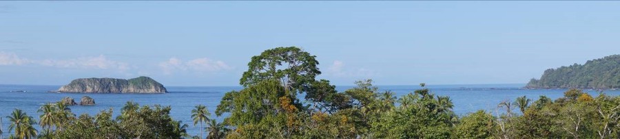
The main tourist attractions are the four beaches Espadilla Sur, Manuel Antonio, Escondido, and Playita.
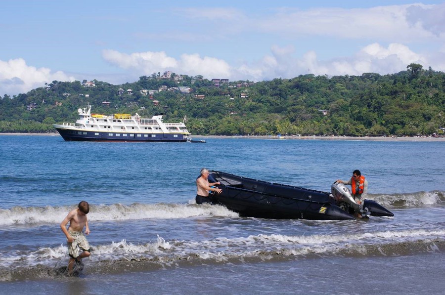 Tourism along the coastline of Manuel Antonio National Park.
Box 2: Cahuita National Park
The Cahuita National Park is located in the Caribbean La Amistad Conservation Area of Costa Rica, part of the southern Caribbean coast in the Limón Province, and connected to the town of Cahuita. It covers 1.068 hectares of terrestrial areas, 600 hectares of coral reefs and 22.400 hectares of marine areas. A variety of important habitats and systems including coral reef, sea grass, traditional turtle-nesting beaches, coastal swamp and fringe forest are protected by the park. The beaches and coral reefs attract a large number of tourists each year. Much of the coral reef has been degraded by a combination of human-induced factors and warming of the near-shore coastal waters. Problems of coral bleaching and die-back related to excessive siltation were already known about at the beginning of the 1980s (Cortés & Risk 1984).
The sea grass beds are dominated by two species, Thalassia testudinum (Banks ex König 1805) and Syringodium filiforme (Kützing in Hohenacker 1852-1962) (see Fonseca et al. 2007). In the past, the sea grass system has provided important habitats for breeding fish and feeding sites for manatees (Trichecus manatus). However, recent changes to this ecosystem have degraded the quality of these habitats and resulted in the local extinction of the manatee population along with several of the fish species.
Cahuita is an important site within the region for Echinoderms of which 23 species have been recorded in the park (Bolaños et al. 2005).
The park provides protection for remnant humid tropical forests and also for swamp forests of „Yolillo“ (Aracaceae) and Sangrillo (Fabaceae). Typical inhabitants of the forested areas are white faced capucin monkeys (Cebus capucinus), and crab eating raccoons (Procyon lotor). The park is also home to the nocturnal kinkajous (Potos flavus).
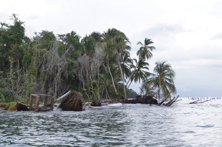 Evidence of rapid coastal erosion taking place throughout Cahuita National Park.
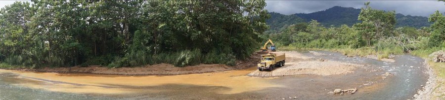 Gravel extraction taking place on Río Portalón, which disembogues in Manuel Antonio National Park.
Results
Both sub-groups began the exercise by examining the ecological integrity of the site in the wider context of land use change and management. There was broad consensus amongst all participants from both parks that current boundaries delineating protected areas were too small to effectively meet the conservation objectives and that they should be extended to include watersheds, river basins and littoral as well as deeper zones out at sea. It was also clear from discussions amongst members of each group that most of the risks and impacts to biodiversity within the reserves came from outside the park boundaries. For example, the sedimentation and contamination that threatens marine life in both parks were the combined effects of degraded river systems and intensive agricultural production in the surrounding areas. In the case of Manuel Antonio National Park, the team members included in their strategy the need to manage the activities of land owners and industry operating in the wider landscape. For these reasons, both protected areas decided to increase the boundaries of their planning area with the specific intention of incorporating the headwaters of rivers as these were identified as the main source of sedimentation in the marine areas.
While both parks already had a strategy for regulating visitor numbers and other human activities it was clear from evidence of the Manuel Antonio National Park that effective policing of tourism remained a challenge. An adjustment to existing strategies for managing tourism was seen necessary in both parks.
Both groups adopted an ecosystem approach when it came to selecting biodiversity objects, although certain priority species were incorporated into the list. Direct reference was made to one or two species such as turtles. Staff at Manuel Antonio National Park raised concerns about the serious lack of information and knowledge of the marine biodiversity, which may have accounted for a poor representation of this biodiversity group in the initial list of conservation objects.
The final results of the situation analyses, in both cases, revealed several gaps in existing management strategies. For instance, climate change was identified as a major threat that would have a growing impact on almost all conservation targets in years to come and yet there was little reference to climate change in the original management documents. The Cahuita team identified the need for urgent fiscal aid to help resolve the complex problem of human disturbance and climate change impacts on beaches that were eroding and degrading existing turtle nesting grounds. The Manuel Antonio team proposed a climate change adaptation strategy that would have relevance to all conservation activities including the current tourist plan.
In rating existing and new strategies almost all proposals were awarded high values. The Cahuita team chose to abandon the existing strategy for dealing with invasive species as this problem was considered to be a lower priority to other concerns and because resources to tackle the issue were limited. All other existing strategies were considered to be either viable or in need of minor alterations to improve their success rate.
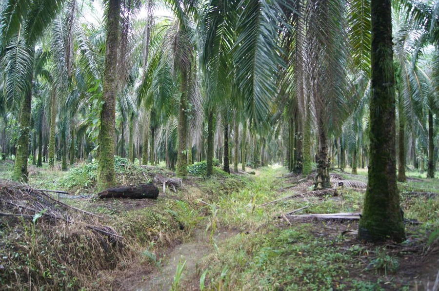 Ditch cutting through a palm oil plantation, south-east of Manuel Antonio National Park.
Box 3: Complexly interacting threats in the marine and terrestrial environments in Manuel Antonio and Cahuita National Parks
Peter R. Hobson & Pierre L. Ibisch
As part of the Ecosystem Diagnostics Analysis during the brief visit to both Manuel Antonio and Cahuita National Park the key environmental problems observed were recorded and summarised as follows:
- Direct and indirect effects of natural resource management, specifically, rivers;
- Direct and indirect effects of land use with a focus on palm oil and banana plantations; and
- Interacting effects of directly human-induced threats and climate change (salt dilution effects of river plus sea temperature increase; pesticide and eutrophication plus temperature increase etc.).
Later during the vulnerability workshop these problems were confirmed.
Rivers and water quality
Both, Manuel Antonio and Cahuita, National Parks are situated in close proximity to medium sized rivers, and both parks receive substantial quantities of river sediment as a result of ocean current movements and long-shore drift. The cause of surplus sediment ‘outwash’ in both sites is a result of the impacts of river engineering, in-stream gravel mining, and the importation of excess flood plain run-off channelled through the numerous dykes and creeks featured throughout all the adjoining plantations. Physical modification that includes in-stream gravel extraction and the construction of flood banks can have a number of long-term effects on the whole catchment basin (Melton 2009). Gravel extraction for purposes of building construction or flood defences increases the transport of sediment, sediment suspension and gravel siltation (Rundquist 1980, OWWRI 1995). The alteration of the river channel and removal of natural armouring creates a large amount of fine sediment that is then moved through the system more rapidly. Increased velocity of water with higher sediment loads accelerates the further break down of the river bed with the loss of deep pools and the creation of more braiding (e.g., Melton 2009). Water quality is also affected as nutrients attach themselves to particles and accumulate over time. Excessive nutrient loads reduce water oxygen levels, promote algal growth and decrease the clarity and quality of the water. Where there are small village settlements along the river with poor sanitation infrastructure the problem is greatly exacerbated by the continual seepage of raw effluent that may persist to the point at which it exits into the marine environment. This was evident from observations made at both national park locations. Sedimentation in coastal marine habitats brought on by natural extreme events or human disturbance can have acute and chronic lasting effects on the biodiversity and function of ecosystems. In particular, the activities of human development can greatly increase sediment load and turbidity in coastal waters and this can have adverse effects on the abundance and diversity of fish (Amesbury 1982). The coupling effects of nutrient and sediment influx and increased turbidity reduces coral cover and species composition, reduces growth rates of many species, and causes death in many others (Weiss and Goddard 1977).
Levels of turbidity were noticeably high in both parks. Notwithstanding the natural seasonal changes in the clarity of in-shore waters, other indicators including widespread siltation on rock surfaces in both the literal and sub-literal zones and the marked absence of macro-algae, mollusc, crustacea and cnidarians species (all indicators of good water quality) reinforced concerns about the large-scale problems of sedimentation.
Large-scale management of palm oil and banana plantations
Maximum yields in palm oil and banana production are achieved by growing plantations in low lands and on well-drained flood plains. In Costa Rica, the high rainfall and prevalence of rivers and creeks necessitates the construction of elaborate ditch and dyke systems to take off surplus water and prevent water logging. Most of the palm oil plantations visited in the countryside around Manuel Antonio National Park were either mature, well established stands or were second rotation crop. There was little evidence of banana cultivation as most had been lost to the development of tourism (Honey et al. 2010). In contrast, banana crops are grown in extensive plantations across flood plains of the rivers north of Cahuita National Park, especially Río La Estrella. To avoid inundation during periods of flooding a sophisticated drainage system has been constructed that extends throughout the croplands, remaining flood plain and linking up with the main creeks and rivers. Field observations confirmed the existence of widespread drainage networks in all oil palm and banana plantations on both sides of the country. In the former case, large ditches, up to 1.5m in depth and 4m in width, were spaced in parallel formation at approximately 20m apart. These were fed by more numerous smaller channels cut out in ‘herring-bone’ design throughout the plantations. The larger channels were regularly ‘slobbed’ out and the channel sediment dumped in piles along each cutting. In some cases, the ditches were kept clear of vegetation by the use of herbicide. The team observed large flood banks abutting oil plantations that had recently been repaired but not before the plantation had suffered severe inundation. A number of the larger creeks running through the banana plantations on the Caribbean coast were managed using substantial sluice gates. Whilst these structures provided a quick response solution to problems of extreme flooding they also introduced erratic flood-pulse patterns into the system that could change the natural dynamics of rivers by promoting the build-up of sediment in ‘back-up’ water and then rapidly releasing this into the system between periods of flooding. Large discharging of water into river and estuarine systems can result in localised erosion along river banks and shore lines.
The palm oil trees are treated with a range of pesticides to reduce infestation, including rodenticides (flocoumafen and brodifacoum), insecticides (rhynchophorol), nematocides and fungicides (Vásquez et al. 2006). Evidence in the field indicated that each tree was spot-sprayed to remove vegetation from around the base of the tree possibly as a measure of reducing root competition from lianas, and to secure the site from dangers of insect and snake bites. In some cases vegetation undergrowth was kept down by cattle grazing.
Coupling effects of ‘conventional’ threats and climate change
Coastal and marine ecosystems are main areas of concern as evidence indicates a rapid warming of the seas and a change in ocean chemistry (e.g. Anthony et al. 2008). The vulnerability of coral reefs off the Caribbean coastline has caused widespread concern amongst scientists. Increases in atmospheric CO2 concentrations is changing the ocean chemistry, which is contributing to the alteration in the structure and functioning of the marine ecosystem. In particular, coral reefs are highly sensitive to even slight increases in temperature and are showing evidence of bleaching, followed by death. This is not the only cause of coral bleaching. Elevated levels of CO2 in the atmosphere are also affecting the quantity of dissolved CO2 in the seas and this is increasing acidification of sea water, leading to coral bleaching and death. The combination of warmer waters, acidification and chemical pollution from agricultural run-off is resulting in the transformation of reefs into algal-dominated communities with a much reduced biodiversity. Other changes include temperature-enhanced eutrophication that is promoting algal growth and an increase in water turbidity. This is restricting light levels around coral reefs and bringing about their demise. Warmer sea water is also interacting with the dilution effect from excess river water brought about by ‘over-active’ drainage systems in the plantations. The combined affects maintain the high levels of suspended solids in the water that drifts on inshore currents across the coral system, sea grass beds and biogenic reefs before depositing out in these ecosystems. It is unclear whether all these combined factors are the primary cause of altered beach dynamics and coastal erosion witnessed along the Caribbean coastline. However, it is safe to assume that the gross degradation of large biological structures such as sea grass beds, biogenic reefs and coral formations will only speed up the chronic effects of climate change.
Climate change-induced alterations to local weather patterns towards more unpredictable strong rainfall events are adding to the existing problems of river catchment dynamics. Future scenarios are likely to include elevated levels in river sedimentation and particulate suspension in coastal waters.
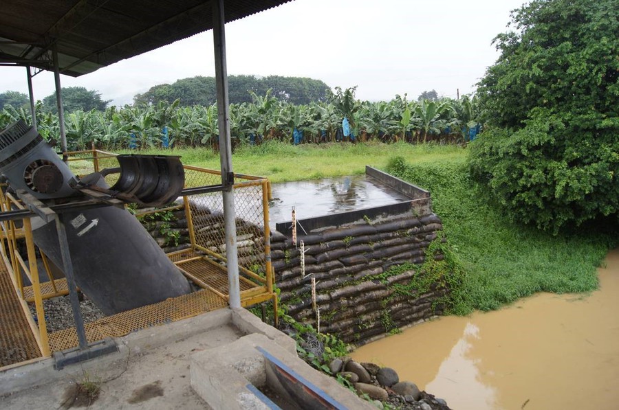 Large sluice gate used to regulate flood water on one of the main creeks that receives run-off from the extensive ditch network in a large banana plantation not far from Cahuita National Park.
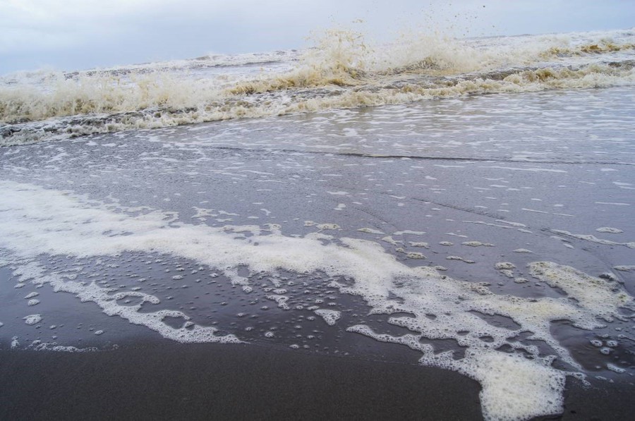 ‘Frothing’ and flotsam in the surf on the coastline just north of Cahuita, December 2012
Outcomes and Conclusions
The in-depth analysis was a novelty for most of the participants, even for those staff with previous experience in planning workshops. Some participants felt that the method was too complicated and time consuming although both teams agreed that the systematic approach provided an effective and realistic analysis of the situation. In particular, time commitment was recognised as a real issue and constraint by the teams of scientific and technical consultants employed to provide the necessary expertise and to produce the management plans. Often, they would “dive out” of the process to attend to other duties and work, thus disrupting their own understanding of the process. Furthermore, the strategies that emerged from carrying out this process were regarded as a true reflection of the problems faced by both parks.
It is worthwhile stressing that the findings emerging from the MARISCO workshop provided the science consultants with important information needed to produce the new management plans for both areas. The conceptualisation and situation analysis highlighted previously underestimated problems connected to climate change and also encouraged participants to analyse both protected areas within a much larger landscape setting.
Both areas have similar problems to do with the funding and staffing of the parks. In some cases, a pragmatic approach to resolving resource limitations is being adopted by collaborating with external partners such as universities or individual researchers. A similar approach will be needed for regional strategies that focus on land-use planning and the integral management of watersheds. The regional conservation areas in Costa Rica provide a useful starting-point to begin a process of large spatial planning.
The participants understood very well the problems of climate change and the synergies with more local human-induced problems. The methodology helped the participants to understand more clearly that most of the solutions to the threats and stresses identified in the park had to involve stakeholders and the wider community living outside the park boundaries.
The advantages of running a large workshop made up of staff from two separate national parks were clear: It provided opportunities for peer review to take place; the sharing of experiences and knowledge; as well as the demonstration of good practice. Collective decisions on common issues and problems could also be made.
In a final evaluation of the effectiveness of the MARISCO workshop participants from both protected area working groups shared the opinion of one member who claimed: “The methodology was clear and is an excellent way of assessing threats, stresses and strategies. It is possible to reach clear conclusions on how to solve existing problems, the results of these workshops need to be included in the new management plan for our area”. An opinion shared by most of the park staff was a common sense of impotence concerning problems arising from outside the park. In particular where large corporation farming was involved. These landscape – related problems relate to other views voiced about the need for assistance at higher levels to address any one of the problems relating to regional scale threats. In the written feedback comment of one participant, it was stated: “There is the need for a workshop that is directed at the level of conservation areas, as many of our strategies need to be focused at regional level”.
References
Amesbury, S. S., 1982. Effects of turbidity on shallow-water reef fish assemblages in Truk, Eastern Caroline Islands. Manila. University of the Philippines.
Andam, K.S., Ferraro, P.J., Sims, K.R.E., Healy, A. and Holland, M.B., 2010. Protected areas reduced poverty in Costa Rica and Thailand. Proceedings of the National Academy of Sciences of the United States of America, [online] Available at: http://www.pnas.org/content/107/22/9996.full.pdf+html [Accessed 19 September 2014].
Anthony KR, Kline DI, Diaz-Pulido G, Dove S, Hoegh-Guldberg O (2008)Ocean acidification causes bleaching and productivity loss in coral reef builders. Proc Natl Acad Sci U S A 105: 17442–17446
Bolaños, N., Bourg, A., Gómez, J. and Alvarado, J.J., 2005. Diversidad y abundancia de equinodermos en la laguna arrecifal del Parque Nacional Cahuita, Caribe de Costa Rica. Rev. Biol. Trop. Int. J. Trop. Biol.,53 (3), pp. 285-290.
CIA The World Factbook, 2014. Central America and Caribbean: Costa Rica. [pdf] Available at: https://www.cia.gov/library/publications/the-world-factbook/geos/print/country/countrypdf_cs.pdf [Accessed 19 September 2014].
Fonseca, A.C., Nielsen, V. and Cortés, J., 2007. Monitoreo de pastos marinos en Perezoso, Cahuita, Costa Rica (sitio CARICOMP). Rev. Biol. Trop. Int. J. Trop. Biol. 55 (1), pp. 55-66.
Melton, B.P.E., 2009. In-stream gravel mining impacts and environmental degradation feedback associated with gravel mining on the Rio Tigre of the OSA peninsula, Costa Rica, and the proposed ADI Jimenez Gravel Mining Concession. Austin: Melton Engineering Services.
OWWRI, Oregon Water Resources Research Institute, 1995. Gravel disturbance impacts on salmon habitat and stream health. Vol. 1: Summary Report.
Rundquist, L.A., 1980. Effects of gravel removal on river hydrology and hydraulics. In: Woodward-Clyde Consultants, ed. 1980. Gravel removal studies in arctic and subarctic floodplain in Alaska. Washington, D.C.: Fish and Wildlife Services, U.S Department of the Interior. pp. 67-140.
Salazar, J.A., Varela, G., Jiménez, G., Rodríguez, M.A., Gutiérrez, R., Cháves, R., Artavia, G., Heiner Acevedo M. and Luis Paniagua Ch., 2005. Plan de Manejo para el Parque Nacional Manuel Antonio. Santo Domingo de Heredia: ACOPAC-INBio.
Vásquez, J., Gómez,F. and Meneses, N., 2006. Linking Ridges to Reef: Promoting better management practices among oil palm producers in the Sula valley region of Northern Honduras. WWF.
Weiss, M.P. and Goddard, D.A., 1977. Man’s impact on coastal reefs: an example from Venezuela. In: Forst, S.H., Weiss, M.P. and Saunders, J.B., eds. Reefs and related carbonates: Ecology and Sedimentation. Tulsa: American Association of Petroleum Geologists. pp. 111-124.
Honey et al. 2010,
Impact of Tourism Related Development on the Pacific Coast of Costa Rica Summary Report By: Martha Honey Erick Vargas William H. Durham Center for Responsible Travel A Nonprofit Research Organization Stanford University and Washington, DC www.responsibletravel.org April 2010
http://www.responsibletravel.org/resources/documents/Coastal-tourism-documents/Summary%20Report/Summary_Report_-_Impact_Tourism_Related_Development_Pacific_Coast_Costa_Rica.pdf
Las Baulas de Guanacaste National Marine Park, Costa Rica
Sven Bratschke & Rotney Piedra Chacón
General setting
The MARISCO methodology was applied as a central approach in the context of of a Master thesis whilst studying for a qualification in Global Change Management (M.Sc.) at the Eberswalde University for Sustainable Development, Germany. The hypothesis of the Master thesis was that MARISCO is a valuable method for designing and integrating ecosystem-based adaptation strategies into nature conservation plans. Moreover, it was assumed that institutional aspects represent the key constraints for the effective implementation of Ecosystem-based adaptation (EbA) strategies in the case study area. The research was carried out in 2013 at the Las Baulas de Guanacaste National Marine Park (Parque Nacional Marino Las Baulas de Guanacaste; hereafter PNMLB), Costa Rica in partnership with BIOMARCC (Marine and Coastal Biodiversity, Capacity Building and Climate Change Adaptation in Costa Rica)[1] and the consulting firm Sostenible por Naturaleza (SpN).
The MARISCO methodology was integrated by the project BIOMARCC as a central approach for the design of management plans (see also chapter B-V).
Box 1: Las Baulas de Guanacaste National Marine Park
Las Baulas de Guanacaste National Marine Park (PNMLB) is located in the north-western part of Costa Rica on the peninsula of Nicoya. It falls within the province of Guanacaste, the canton of Santa Cruz as well as to the districts of Cabo Velas and Tamarindo (Tiffer-Sotomayor et al., 2004). PNMLB was established in 1991, although some of the current boundaries were already declared as Wildlife Refuge in 1987 (Decreto Ejecutivo 17566, 1987; Decreto Ejecutivo 20518, 1991). The national parks in Costa Rica are managed by the National System of Conservation Areas (SINAC) which is further structured and divided into national, regional and local administrative units. PNMLB is part of the Tempisque Conservation Area and administered by a local management authority in Playa Grande (SINAC, 2013).
The terrestrial part of the national park is 9 km2, whilst the marine area covers approximately 252 km2 (SINAC, 2014, p.7). The land-side of the park is formed of sandy beaches, mangroves and the coastal vegetation along the beaches that collectively make up the coastal plain positioned between the sea and a backdrop of individual hills (Astorga Gättgens et al., 2008). These isolated hills reach a maximum altitude of 215 meters (GEOCAD, 2009). The climate of the area is classified as tropical savanna climate with an annual average temperature of 26°C to 28°C and an average annual precipitation between 1,500mm and 1,750mm. The El Niño-Southern Oscillation (ENSO) strongly influences the climatic conditions of the area (IMN and CRHH, 2008; IMN, 2005a and b). PNMLB belongs to the life zone of tropical dry forest in transition to humid (Tiffer-Sotomayor et al., 2004).
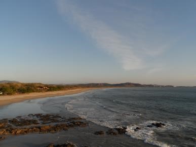 View on Playa Grande, main marine turtle nesting beach of PNMLB
About 40 years ago the area around PNMLB was mostly dominated by agricultural activities and characterised by a few local and family-based farms. Since the 1980s the area has undergone a drastic, mostly unplanned and environmentally inadequate, change with the development of touristic facilities, infrastructure and real estate (Camps et al., 2008; Morera and Matamoros, 2003; Tiffer-Sotomayor et al., 2004). Nowadays, the area is one of the main tourist destinations in the country and is further characterised by a high number of foreign residents as well as social disparity (INEC, 2011).
PNMLB is considered to be the main nesting site for the critically endangered population of Eastern Pacific leatherback turtles (Dermochelys coriacea) in Central and Northern America. Illegal fishing , poaching, pollution and the inadequate coastal development are major threats that significantly endanger the flagship species of the National Park (Santidrián Tomillo et al., 2008; Spotila et al., 2000). The main reason for designating the area a national park was to protect the nesting beaches and the inter-nesting marine area, and to stop the uncontrolled development of the region. (Pritchard, 1991). Despite conservation efforts, nesting female numbers have declined dramatically from more than 1,500 to about 30 individuals per nesting season within the last 25 years (Piedra, 2011). Climate change does represent an additional threat to the survival of the population (Saba et al., 2012; Santidrián Tomillo et al., 2012; IUCN, 2009).
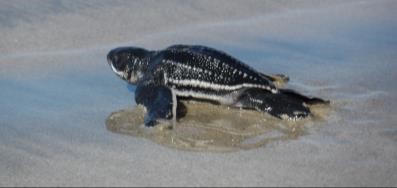 Leatherback turtle hatchling at Playa Grande on its way to the ocean
Besides the nesting beaches and the inter-nesting marine area, PNMLB does also protect areas of tropical dry forest and wetlands, such as the wetland of Tamarindo, which has been declared as a RAMSAR site in 1993 (Ramsar and Wetlands International, 2013).
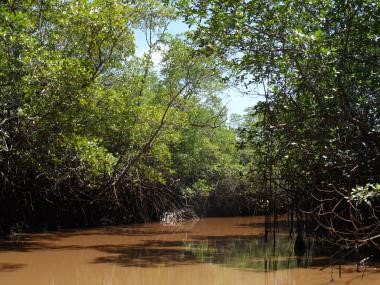 The estuary of Tamarindo and mangroves
Workshops and workflow
Prior to the MARISCO workshops, a detailed literature review on the biodiversity objects of PNMLB as well as on climate change scenarios and the potential impacts on the defined objects was conducted. Due to resource constraints, not all MARISCO workshops included external stakeholders. Consequently, the multi-stakeholder and participatory workshops were supported by additional technical workshops, in order to finalise the vulnerability assessment as well as the identification and evaluation of strategies.
The multi-stakeholder and participatory workshops were delivered on 24 July 2013, and later on the 16-17 August 2013 in the local administration office of PNMLB. Between 28 and 37 representatives from different governmental, public and private institutions (SINAC, BIOMARCC, Coast guards, Communitarian Development Associations, NGOs, Hotels, Community-based association of aqueducts and sewerage, municipalities) as well as individual community members and property owners took part in both workshops. Participants began the process by defining the scope, vision and the conservation objects for PNMLB. In a next step a systemic vulnerability and risk analysis was carried out by identifying stresses, threats and contributing factors to the different conservation objects. The tasks were performed in small groups due to the high number of participants present. Each group presented their results to all the participants and opened up the floor for discussion. Results were then visualised through the use of moderation cards and the creation of a conceptual model. In the final summation the results from both workshops were discussed and evaluated within the technical workshops.
[1] The project BIOMARCC of the Deutsche Gesellschaft für Internationale Zusammenarbeit (GIZ) GmbH, in cooperation with the National System of Conservation Areas (SINAC in Spanish initials) in Costa Rica, is currently carried out under the International Climate Initiative (ICI) of the German Federal Ministry for the Environment, Nature Conservation and Nuclear Safety. Central objective of the project is to increase the adaptive capacity of the coastal and marine ecosystems in Costa Rica to the adverse impacts of climate change. One main aspect in order to achieve the objective is to assist coastal and marine protected areas in the design of management plans which consider impacts of climate change and integrate adaptation strategies (BIOMARCC-SINAC-GIZ, 2013). See also http://www.biomarcc.org for more information.
 Figure 4. Participants discussed the current scope in small break-out groups by using a map with the defined scope of the former management plan
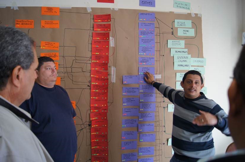
In August 2013, five technical workshops were organized for the completion of the final stages of MARISCO and also to confirm the results from the multi-stakeholder meetings. The number of participants varied from 7 to 11 and included representatives from the administration for PNMLB, the regional office of SINAC, BIOMARCC and SpN. In a first step, the conceptual model was revised, complemented and finalised based on the input from the multi-stakeholder workshops. Most of the steps and discussions were realised in plenary sessions. The assessment of elements within the conceptual model was however divided into two groups due to time constraints.
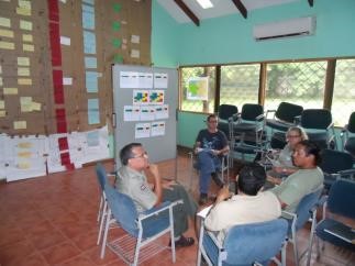 Figure 5. Participants in the technical workshop discussed and evaluated the criticality, knowledge and manageability of all elements generating vulnerability
The completed conceptual model and the strategy matrix were shared between all the participants for discussion A SWOT-Analysis based on interviews with local employees as well as a detailed literature review on climate change conditions scenarios and impacts in the region were used as complementary methods.
Results
Seven biodiversity objects from both marine and terrestrial ecosystems were identified in the exercise. The initial scoping exercise confirmed in the minds of the participants that almost all the factors impacting negatively on the biodiversity within the national park were from outside the protected area. The solution was to extend the boundaries of analysis to include a much larger area of watershed However, park employees also acknowledged there were resource-related issues arising from within the management of the park that were contributing to critical threats to biodiversity. Of all the critical threats identified in the analysis climate change related problems were considered to be some of the most important. Of particular note was the reference made to the threat to marine turtles caused by the indirect effects of climate change on sea level rise and loss to coastal nesting sites Wider concerns to biodiversity loss from climate change impacts were not raised during the workshop Evidence for the impacts of climate change on local biodiversity was supplemented by the desktop study carried out in the lead-up to the workshops, which was then incorporated into the situation analysis. Unregulated tourism and real estate development, together with a range of other human-induced problems such as pollution, over-fishing uncontrolled water abstraction were included as critical threat factors. Results for the vulnerability assessment indicated that the knowledge about the marine ecosystem was poor and that existing conservation efforts focused on the terrestrial landscape. Most participants identified the lack of human and financial resources as principal constraints to the implementation of effective conservation measures. The SWOT-Analysis also acknowledged there were internal and external institutional challenges relating to collaboration, cooperation and communication, which further hindered effective management for conservation.
The lack of financial and human resources identified in the analysis prompted the decision to reduce the number of proposed strategies from the former management plan and focus on the implementation of the most relevant strategic actions. Some of the existing strategies were supplemented with new devised objectives including measures taken to enhance adaptation to climate change as well as an Integrated Water Resource Management plan.
Outcomes and conclusion
The feedback from participants about the value and usefulness of MARISCO indicated overall satisfaction with the process in meeting objectives of producing a new management plan for PNMLB. Specific positive aspects of the method mentioned were the step-wise procedure and visual format for the conceptual model. Participants also acknowledged the value of of full participation of stakeholders, the knowledge sharing within the workshops and the strong focus on all relevant ecosystems. The environment generated by working with MARISCO enabled participants to discuss their different point of views and also provided an appropriate platform for conflict resolution.
Some participants in the multi-stakeholder workshops had difficulties perceiving the site and potential future threats, and preferred to focus on current highly critical threats. This suggests there continues to be difficulties amongst practitioners in working with scenario-based deductive analysis that purposefully integrate uncertainties into nature conservation practices. This was particularly true for the technical workshop, which was attended by few participants, all suffering from high workloads. With this in mind, the recommendation would be to reduce, simplify and adapt some of the steps to help resolve problems relating to shortages of time and money.
Logistical problems to do with large and diverse group sizes and the experience of facilitators to manage the method under such conditions affected the quality of the outcomes. To ensure consistency in quality of delivery and outcomes would require regular training and up-dating of skills amongst trainers working in the field under difficult conditions and across a diversity of cultures. Nonetheless, all proposed strategies by participants mainly target the elimination or mitigation of the most critical underlying drivers and contributing factors of human activities which negatively impact the ecosystems and their respective services. Thus, all strategies contribute towards ecosystem-based adaptation by reducing the vulnerability and increasing the adaptive capacity of ecosystems with regard to threats of climate change and human activities.
However, in order to enable an effective management for PNMLB and realise the proposed ambitious EbA measures, it will be of major importance to overcome current challenges. This especially refers to the lack of resources and the general weak collaboration with external stakeholders. The local nature conservation authority alone will not be able to eliminate all negative aspects affecting the ecosystems. Thus, it will be of central importance to harmonise the current development agenda of the region with the necessities of the natural environment. A holistic approach, which focuses especially on the interconnection of the terrestrial, coastal and marine ecosystems and which combines regional development planning with biodiversity conservation by fostering a more collaborative management approach is required, in order to effectively protect the ecosystems of PNMLB. MARISCO has revealed the need for a stronger focus on analyzing and managing ecosystems as integrated parts of a larger whole. It has also encouraged stakeholders to adopt a more future-oriented vision that incorporates risks, a stronger integration of and cooperation with external stakeholders, and the consideration of climate change aspects into long-term planning. It is assumed that these aspects require a paradigm shift in current nature conservation practices and development planning on the local and national level.
In conclusion, it can be shown that MARISCO represents a valuable approach in the design and integration of ecosystem-based adaptation strategies in the management planning for protected areas.. The SWOT-Analysis and the climate change vulnerability assessment provided complementary information to the outcomes of the MARISCO workshop. The overall output of the exercise suggests both approaches work well when applied together in cases where institutional and climate change threats and stresses are not fully represented in the results of the workshops and a more in-depth analyses of these aspects are required. Based on the outcomes of the workshop the recommendation is to highlight the importance of climate change aspects throughout the facilitation of the MARISCO process. All generated results at PNMLB should be constantly reviewed by workshop participants and external experts on an annual basis, in order to validate and update the generated results. Moreover, the application of additional MARISCO steps such as the identification of key ecological attributes, the spatial analysis of threats and strategies as well as the definition of result webs will be beneficial, in order to revise and complement the situation analysis and strategies for PNMLB.
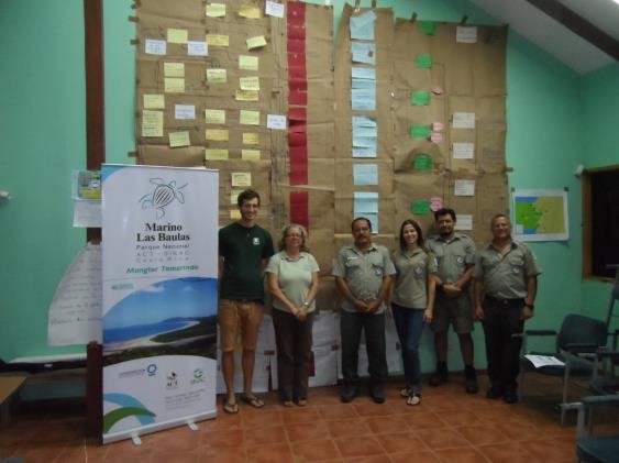 Figure 7. Participants of the technical workshop in front of the generated conceptual model
References
Astorga Gättgens, A., A. Mende, M. Rodríguez and M. Piedra González, 2008. Evaluación de la condición ambiental actual de la comunidad de Tamarindo y áreas aledañas, Santa Cruz, Guanacaste, Costa Rica. Aplicación del metódo del indice de fragilidad ambiental y del análisis de alcance ambiental con enfasis en la evaluación de effectos acumulativos. San José: SETENA.
BIOMARCC-SINAC-GIZ, 2013. Análisis de vulnerabilidad de las zonas oceánicas y marino-costeras de Costa Rica frente al cambio climático. San José: BIOMARCC-SINAC-GIZ.
Camps, A., A. Montserrat, C. Porras and A. Rovira, 2008. Transformaciones físicas y socioeconómicas a causa de la implantación turística en la localidad de Tamarindo, Costa Rica. [pdf] Available at: <http://dugi-doc.udg.edu/bitstream/handle/10256/1073/1%20MEMORIA.pdf?sequence=1> [Accessed 19.10.2013].
Decreto Ejecutivo 20518, 1991. Decreto ejecutivo de Crea Parque Nacional Marino Las Baulas Guanacaste. Diario Oficial La Gaceta 09 July 1991. N°129.
Decreto Ejecutivo 17566, 1987. Decreto ejecutivo de Crea Refugio Nacional de Vida Silvestre Tamarindo. Diario Oficial La Gaceta 23 June 1987. N°118.
GEOCAD, 2009. Estudio integral sobre el impacto de las construcciones y el desarrollo turístico y urbanístico en la zona de amortiguamiento del Parque Nacional Marino Las Baulas Tamarindo, Cabo Velas, Santa Cruz, Guanacaste. [unpublished preliminary report] San José: SETENA.
IMN and CRHH. Instituto Meteorológico Nacional and Comité Regional de Recursos Hidráulicos, 2008. El clima, su variabilidad y cambio climático en Costa Rica. [pdf] San José: Instituto Meteorológico Nacional. Available at: <http://cglobal.imn.ac.cr/sites/default/files/documentos/el_clima_variabilidad_y_cambio_climatico_en_cr_version_final.pdf> [Accessed 22 October 2013].
IMN. Instituto Meteorológico Nacional, 2005a. Temperatura media anual en Costa Rica, 1:1500000. Atlas Climatológico de Costa Rica. [online] Available through: <http://www.imn.ac.cr/mapa_clima/interactivo/index.html> [Accesed 22 October 2013].
IMN. Instituto Meteorológico Nacional, 2005b. Evaporación de referencia media anual en Costa Rica en mm/año, 1:1500000. Atlas Climatológico de Costa Rica. [onlinr] Available through: <http://www.imn.ac.cr/mapa_clima/interactivo/index.html> [Accesed 22 October 2013].
INEC. Instituto Nacional de Estadísticas y Censos, 2011. Resultados generales del censo 2011. [online] Available at:< http://www.inec.go.cr/Web/Home/GeneradorPagina.aspx> [Accessed 01 November 2013].
IUCN. International Union for Conservation of Nature, 2009. Species and climate change. More than just the polar bear. [pdf] Gland, IUCN. Available at: <https://cmsdata.iucn.org/downloads/species_and_climate_change_1.pdf> [Accesed 08 October 2013].
Morera, S. and G. Matamoros, 2003. Evaluación del potencial y demanda hídrica subterránea en el acuífero costero Huacas-Tamarindo, Santa Cruz, Guanacaste, Costa Rica. San José: SENARA.
Piedra, R., 2011. Evaluación del éxito de incubación de los huevos de tortuga baula (Dermochelys coriacea) en dos áreas de anidación del Parque Nacional Marino Las Baulas de Guanacaste y su aporte a la conservación de la especie en el pacífico oriental tropical. MSc. Universidad Nacional de Costa Rica.
Ramsar and Wetlands International, 2013. The Ramsar Sites Database. Search for sites. [online] Available at: <http://www.ramsar.wetlands.org/Database/SearchforRamsarsites/tabid/765/Default.aspx> [Accessed 19 October 2013].
Saba, V.S., C.A. Stock, J.R. Spotila, F.V. Paladino and P. Santidrián Tomillo, 2012. Projected response of an endangered marine turtle population to climate change. Nature Climate Change, 2(11), pp.814-820.
Santidrián Tomillo, P., V.S. Saba, G.S. Blanco, C.A. Stock, F.V. Paladino and J.R. Spotila, 2012. Climate driven egg and hatchling mortality threatens survival of eastern pacific leatherback turtles. PLoS ONE, 7(5) :e37602. doi:10.1371/journal.pone.0037602.
Santidrián Tomillo, P., V.S. Saba, R. Piedra, F.V. Paladino and J.R. Spotila, 2008. Effects of illegal harvest of eggs on the population decline of leatherback turtles in Las Baulas Marine National Park, Costa Rica. Conservation Biology, 22(5), pp.1216-1224.
SINAC. Sistema Nacional de Áreas de Conservación del Ministerio de Ambiente y Energía, 2014. Diagnóstico para el Plan General de Manejo del Parque Nacional Marino Las Baulas. Eds H. Acevedo and E. Vargas. Santa Cruz, Costa Rica.
SINAC. Sistema Nacional de Áreas de Conservación del Ministerio de Ambiente y Energía, 2013. Área de Conservación Tempisque. [online] Available at:< http://www.sinac.go.cr/AC/ACT/Paginas/default.aspx> [Accessed 21 October 2013].
Spotila, J.R., R.D. Reina, A.C. Steyermark, P.T. Plotkin and F.V. Paladino, 2000. Pacific leatherback turtles face extinction. Fisheries can help avert the alarming decline in population of these ancient reptiles. Nature, 405(6786), pp.529-530.
Tiffer-Sotomayor, R., R. Piedra, G.N. Rodríguez, A. Rosales, C. Diaz, G. Briceño, A. Fonseca, B. Cortés and C. Chang, 2004. [unpublished] Plan de acción del plan de manejo del Parque Nacional Marino las Baulas de Guanacaste 2005-2010. Área de Conservación Tempisque. San José: Centro Científico Tropical.
Tiffer-Sotomayor, R., A. Mata, M. Losilla, S. Cervantes, M.V. Cajiao, M. Adamson, R. Araúz and M. Marín, 2003. [unpublished] Diagnóstico Ambiental del Parque Nacional Marino Las Baulas de Guanacaste. Plan de Manejo del Parque Nacional Marino Las Baulas de Guanacaste – ACT. San José: Centro Científico Tropical.
MARISCO was developed by

MARISCO development and website were supported by
assisted by

© Centre for Econics and Ecosystem Management e.V. - Eberswalde University for Sustainable Development