Case study Germany: Diverse MARISCO applications in Brandenburg, north-eastern Germany
Stefan Kreft, Daniela Aschenbrenner, Lena Strixner, Felix Cybulla & Pierre L. Ibisch
General setting
MARISCO was applied in two projects in the Federal State of Brandenburg, Germany, as part of the research project Adaptation of administrative nature conservation in Brandenburg[1].
The first of these projects was to develop an adaptive nature conservation plan[2] for the District of Barnim. The Lower Nature Conservation Authority (‘Untere Naturschutzbehörde’) requested the Centre for Econics & Ecosystem Managementto revise the existing conservation plan, make the planning procedures more dynamic and encourage the participation of other land use authorities in the region. The MARISCO process superseded previous adaptive management planning exercises using Open Standards for the Practice of Conservation (in the following: Open Standards)[3]. This project is probably the first time an adaptive management approach has been introduced into nature conservation planning at district level in Germany. This is of particular interest in that the project does not just address protected areas, but rather an entire district, i.e. a matrix where conservation goals are not given priority over a multitude of other land uses.
MARISCO was applied in an ongoing reintroduction project of a charismatic bird species, the capercaillie (Tetrao urogallus) in the Lower Lusatia area[4]. The working group of the project, consisting of members from different forest-related sectors (forestry, hunting, state authorities and non-governmental nature conservation organisations), requested the workshop to aid strategic long-term project planning. Although the project deals primarily with the conservation of one particular species, its success is ultimately linked to the existence of sizeable areas of habitat for this species. The typical characteristics of this habitat include the following features: well-structured, old-growth forests in combination with functional peatlands. The project is viewed as a landscape conservation project under the umbrella of a particular species (that represents a nested biodiversity conservation object.

MARISCO applications in Brandenburg.
|
|
Adaptive nature conservation plan for the District of Barnim |
Pilot project for the reintroduction of the capercaillie in Lower Lusatia |
|
Period of planning excercise |
2011-2013 |
February-March 2013 |
|
Main MARISCO phases applied |
Parts of I. and II., examples of III.[5] |
Most of I. and II., examples of III. |
|
Planning team |
Lower Nature Conservation Authority / Government of the District of Barnim |
Working group of the Friends of the Lower Lusatian Heath Landscape Nature Park Association |
|
Planning and management scope |
(A large part of) the District of Barnim |
Forest-peatland landscape mosaic in Lower Lusatia |
|
Size |
89,050 ha[6] |
Approx. 10,000 ha[7] |
|
Types of conservation object s |
|
|
[1] The aim of this project was to adapt current planning and management methods to non-linear and unpredictable climate changes and to introduce adaptive management into current practice. It was part of the consortium Innovation Network of Climate Change Adaptation Brandenburg Berlin (INKA BB). INKA BB was designed to develop cross-sectoral adaptation strategies to the impacts of climate change. The funding period was 2009 to 2014. The CEEM collaborated with Jürgen Peters, Professor for Landscape Planning, Faculty of Landscape Management and Nature Conservation at Eberswalde University for Sustainable Development.
[2] A so-called “Landschaftsrahmenplan”.
[3] Undertaken in the context of the “Junior Researchers Group Regional Adaptation Strategies to an Accelerating Climate Change” and funded by the European Social Fund (ESF; Aschenbrenner et al. 2012)
[4] The pilot project for the reintroduction of the capercaillie in Lower Lusatia runs from 2012 to 2014 and it is funded by the European Agricultural Fund for Rural Development of the EU and the Federal State of Brandenburg.
[5] The Open Standards, as a forerunner to MARISCO, were applied to a varying extent.
[6] Engelhart et al. (1997).
[7] L. Thielemann, pers. comm.
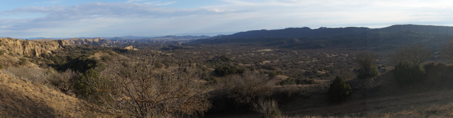
Planning and management areas in Brandenburg, Germany.
Federal State of Brandenburg
Brandenburg is one of the 16 federal states of Germany. It is located in the east of the country, adjacent to Poland, and has a climate typical of the Sub-Atlantic north-eastern lowlands. The landscape is characterised by extensive cover of forests (47 %, compared to the German average of 31 %[1]); large tracts of wetland habitat; and poor soils; and a relatively low human population density. Brandenburg is well known for the comparably good conservation status of its biodiversity. This is reflected by an outstanding complex of protected areas, which comprise 15 of the so-called ‘large protected areas’ (national parks, biosphere reserves and nature parks). Future climate change projections for this relatively dry part of the country are severe and likely to lead to increasing scarcity of water as average seasonal temperatures and likely chances of drought increases.
Scope of the nature conservation plan of the District of Barnim
The District of Barnim is located in the Federal State of Brandenburg, immediately north-east of Berlin, and shares a border with Poland. It has an area of about 1,450 km². It has one of the highest levels of forest cover in Germany (45%). The landscape is characterised by a high diversity of ecosystems formed through glacial processes. The northern part of the planning area of the nature conservation plan is dominated by broad-leaved mixed forest and pine stands, stream valleys, lakes and peatlands. In the south, numerous kettle ponds, murky pools as well as mesotrophic lakes are typical. The south-eastern part is mainly characterised by agricultural land use. A major part of the planning area belongs to the Barnim Nature Park. Further areas are designated Natura 2000 sites.
Lower Lusatia
The Lower Lusatian region forms the northern part of Lusatia, which is shared by the Federal States of Brandenburg and Saxony. Lusatia is a flat region situated to the north of the south-eastern German mountain ranges and lies within the transition zone between Sub-Atlantic and Sub-Continental climates. It is characterised by the prevalence of agriculture on the richer soils of the low-lying areas and by sizeable Scots pine (Pinus sylvestris) and sessile oak (Quercus petraea) forests concentrated in the uplands. Due to limited rainfall, poor soils and history of land use, the forest structure is relatively open, permitting extensive berry-rich undergrowth (e.g. bilberry Vaccinium myrtillus). However, large areas in the eastern half of the region have been heavily impacted by open cast lignite mining. The Lower Lusatian Heath and Lower Lusatian Ridge Nature Parks form the core of the region’s protected area network.
Capercaillie conservation in Lower Lusatia
The capercaillie (Tetrao urogallus), is the largest species of game-bird classified in the pheasant order to be found in Europe. In Central Europe, it is most often associated with well-developed old-growth montane forests. However, historically, there was a lowland population in Lusatia. This population experienced an accelerated decline particularly during the last century, which has been attributed to a variety of factors, including plantation forestry, open cast lignite mining, military training activities and excessive hunting of the bird in the past. [1]. In response to its extinction in 1998 from the area an interdisciplinary working group formed, with the ultimate goal of re-establishing a viable capercaillie population[2]. In 2012, this working group started a 3-year-pilot project with the aim to assess the feasibility of a large and long-term attempt to reintroduce the species by observing the behaviour of individuals translocated from Sweden to the two regional nature parks[3].
[1] Möckel et al. 1999, MLUR (2002).
[2] Naturpark Niederlausitzer Heidelandschaft (2013b).
[3] Naturpark Niederlausitzer Heidelandschaft (2013a).
A) Adaptive nature conservation plan for the District of Barnim:
Procedures
Four workshops were carried out as part of the MARISCO application in the District of Barnim. The workshops were complemented by the documentation of the results obtained from earlier strategic discussions between the Lower Nature Conservation Authority and CEEM, and various outreach activities addressing governmental conservation authorities as well as the scientific audience. Whereas the goal of the first workshop was to develop a consensual conceptual model, the second workshop aimed to assess stresses, threats and underlying factors with regards to their strategic relevance.
The first workshop, lasting a day, consisted of a cross-sectoral expert and stakeholder event. CEEM staff guided the participants from the region through the methodological steps of the Open Standards. Results were produced in breakout groups that addressed four different biodiversity objects: “forest ecosystems”, “freshwater ecosystems and peatlands” and “the cultural landscape”. Each breakout group, guided by one coach, identified threats and contributing factors corresponding to the biodiversity objects. The partial models generated at the end of the session were then presented in the plenary, discussed and elaborated by the whole group[5]. After the workshop, CEEM assembled the model parts to produce an overall conceptual model for the planning region using Miradi, and added any missing elements. In particular, a number of stresses were incorporated in order to complete the picture of the impacts of different threats on biodiversity objects.
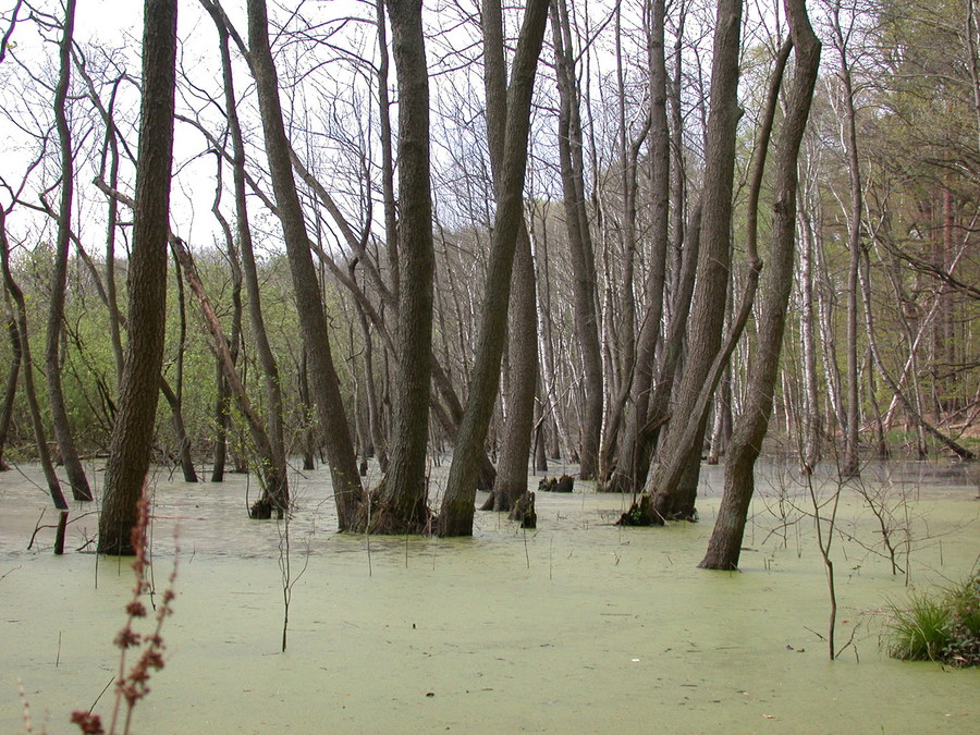
 Functional peatlands are a biodiversity conservation object in the District of Barnim.
Building on the results obtained during the Open Standards workshop, the second and third workshops were run as MARISCO events, working with experts, in order to provide a more detailed assessment of the strategic relevance of the elements in the existing conceptual model. The Lower Nature Conservation Authority were charged with the responsibility of recruiting the assistance of experts with broad knowledge of the forest ecosystem as well as more specific understanding of the ecological requirements of the capercaillie. At this stage of the exercise it was also important to include practitioners who had a good working knowledge of the landscape. A number of experts had already taken part in the first workshop. Initially, participants were divided into two teams each working on stresses and threats/factors related to the species and its habitat. However, after an assessment of progress and concerns about the time taken for each group to make any meaningful progress, it was decided to have single experienced experts carry out tentative assessments, which would then be corroborated by the Lower Nature Conservation Authority and, in a follow-on workshop attended by all experts.
The last workshop again was designed as a cross-sectoral expert and stakeholder event. All results obtained were presented to the participants. Participants were then invited to validate the strategic relevance of all elements (Ibisch & Hobson 2014: 125). Furthermore, workshop participants compiled existing strategies and formulated new strategies, all of which were mapped. Finally, some strategies were assessed.
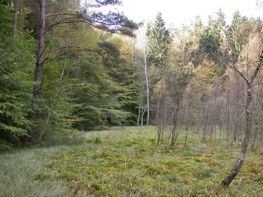
 Close-to-nature, managed beech (Fagus sylvatica) forest in the District of Barnim.
Notable results
I. Preparation and initial conceptualisation
Initially, the Lower Nature Conservation of the District of Barnim was assigned as the planning and management team. Based on “lessons learnt” during the second and third workshops, the agency chose to reconsider this initial decision and extend the task of nature conservation planning and management to include the district government and all its relevant land use agencies. This decision represents a major shift in thinking and planning from the traditional compartmentalised sectoral approach to managing for nature conservation to a more pluralistic, cross-sectoral strategy for nature conservation, integrating all land uses into one ecosystem-based framework.
Management goal-related qualifiers were added to the biodiversity conservation objects. Namely, the general description “forest ecosystems” was reformulated as the more detailed description “resilient, adaptable, well-structured (mixed) broadleaved forests”. In the same vein, reformulation resulted in “(near-) natural surface water, functional peatlands”, and “well-structured cultural landscape”.
II. Systemic vulnerability and risk analysis
The strategic relevance assessment produced very rewarding results, in particular in terms of the reasons given for individual ratings. The ongoing discussion amongst participants yielded valuable information about a range of threats and contributing factors, some of which proved to be contentious. For example, the pros and cons of the intensification of forest use. In other cases the lack of knowledge was considered to be a major factor influencing participant’s final rating for certain factors such as current criticality of construction or upgrading of roads and other traffic connections: second lowest to highest score.
The problems considered by the participants to be the most important were stresses associated with peatlands - eutrophication, mineralisation, and sinking groundwater tables.
Outcomes and conclusions
During the first workshop, the decision to split the group up into smaller breakout groups proved to be beneficial. The workshop participants were able to work with a cleared focus on a particular biodiversity object, and also had the opportunity to discuss in the presence of experts, some of the more detail issues and problems relating to their project area.
While some participants in the second and third workshops cast doubt on the volume of work necessary to carry out complete assessments of all the elements of the conceptual model (see above: Procedures), most experts appreciated the interactive, consensual working style. The systematic approach that builds on a plausible theoretical foundation was also applauded. Regarding the rating method used in MARISCO, there were mixed opinions about its value in the process. Some felt the half-quantitative scoring system was preferable to more exact quantification techniques, suggesting it allowed a more flexible ‘mobilisation’ of experience-based knowledge, and, where desired, an intuitive approach to management issues. Others considered the method to be too qualitative and system of inputting empirical data (evidence-based information) was preferred.
Experts involved in the third workshop emphasised the usefulness of maps and spatial data in assessing the criticality of stresses and threats. In addition, it was recommended to consult specialists when it comes to specific issues such as tree diseases or forest ecosystem water balance.
The criticality assessments gave additional insights into dynamics and future development, and were embraced by all participants. In conclusion and based on the overall feeling of satisfaction with the progress made with the workshops the Lower Nature Conservation Authority decided to support the methodological extension towards MARISCO. It can be concluded that projects using the Open Standards can adopt MARISCO or some of its modules and enjoy added values.
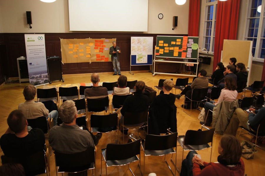 First workshop on district level.
B) Pilot project for the reintroduction of the capercaillie in Lower Lusatia:
Procedures
The workshop followed the standard MARISCO procedure. However, due to the limited amount of time experts could afford to participate the workshop had to be restricted to only two days. Both the site visit and the ecosystem diagnostics analysis had to be dropped, with the hope that the planning team’s excellent knowledge of the project area would compensate for this. Time constraints also necessitated a shortened version to the delivery of the process including: a) Omission of the assessment of past criticality and current criticality, b) Simplification of the assessment of non-knowledge through omission of the two lower (less problematic) ratings, c) The group was divided into two teams to rate the stresses, threats and factors, c) The assessment of strategies was only applied to two strategies as examples.
 Female capercaillie (Tetrao urogallus).
Notable results
1. Preparation and initial conceptualization
The planning and management team was represented by members of the capercaillie working group, which is currently carrying out the pilot project. The team proposed for the management area a wide circle of forest patches around the town of Finsterwalde, including the two nature parks. . Although a connection to another reintroduction project site, approximately 150 km to the east in Poland, was identified as a desirable goal, this was considered of low feasibility, given the ongoing mining activities between the two sites. Therefore, it was decided to bring the issue of metapopulation conservation forward again after the conclusion of the current pilot project. This would then require collaboration with partners in Poland and elsewhere.
The habitat requirements of capercaillie are detailed and complex, and include the mosaic of mires and well-structured pine-oak forests across the region. A wide range of ecosystem services were associated with a successful reestablishment of the targeted bird species. The ecosystem services identified ranged from maximised provisioning and regulating services to motivation and inspiration for conservation and sustainable use of natural resources with regional decision-makers as well as the wider public through identification with the project goals.
II. Systemic vulnerability and risk analysis
The different forest-related disciplines present in the working group enabled a situation analysis of considerable depth and from a diversity of perspectives. Clearly, the many years of experience of a team that has been working together for the same clear goal contributed to the speed and ease of the workshop.
In the course of the assessments of strategic relevance of the elements, one team member identified two, potentially diverging issues. On the one hand, the high profile status of the capercaillie has the potential to rally important decision-makers behind the conservation project. This can count as a strength of the project. On the other hand, the focus on a single species, if its reintroduction should fail, may lead to the total loss of their support. This strength may thus suddenly invert to a distinct weakness of the project. Therefore, it is essential to make sufficiently clear all efforts represent no-regret options, and a recognition of the high benefits derived from conservation action irrespective of the outcomes of the reintroduction programme.
It was unclear amongst the participants whether climate change should be considered at all. Input to this discussion by the workshop moderators was accepted as valid expert opinion, and climate change was accordingly integrated into the conceptual model.
III. Comprehensive evaluation, prioritisation and strategy formulation
Existing strategies were found to address the whole range of elements, from the biodiversity conservation objects through stresses to threats and underlying factors. While these strategies were associated with a number of elements found to be highly relevant strategically, some strategic gaps were also identified. These gaps were then filled by new strategies.
The exemplary assessment of two strategies suggested the strength of a strategy may depend on the ecosystem concerned, in that strategies dealing with forests were judged to perform markedly better than those dealing with mires, the latter being associated with a higher potential of conflicts and risks.
Outcomes and conclusions
Overall, the planning team acknowledged the value of adopting MARISCO to help structure their project ideas. Team members mentioned knowledge management and the strategically structured process as its main virtues, rather than the generation of genuinely new insights. The workshop was appreciated as an opportunity to depart from the business-as-usual quick exchange of piecemeal information, towards a more thorough discussion of the situation. The distinction between stresses, threats and underlying factors was found enlightening in this regard. The ’spirit’ of adaptive management was clearly picked up by the team as demonstrated by the team frequently returning to previous steps in order to change or supplement details.
The two-day workshop was perceived as a fast-advancing, exciting process throughout, which constantly opened up new perspectives. Nevertheless, all participants were aware it had been a hurried exercise, which had made some basically undesirable shortcuts unavoidable. For example, the planning team declared they would have preferred to do all ratings together. According to them, shortage of time also conflicted with the need to learn the MARISCO logic and vocabulary. Another sceptical observation referred to the sometimes varying depth into which elements were analysed.
The planning team expressed their wish to communicate the methodology and the obtained results into the wider circle of the capercaillie working group. A more systematic application of MARISCO in a follow-up project on capercaillie was suggested. The team recommends MARISCO to be used by planning consultancies in Brandenburg and beyond, which would favour more structured management plans. The team sees potential applications also for (vulnerable) systems outside the field of biodiversity conservation.
References
Aschenbrenner, D., M., Welsch, S. Opfermann, J. Peters & P.L. Ibisch (2012): Anwendung des systemisch adaptiven Managementansatzes Offene Standards für die Naturschutzpraxis in der Landschaftsrahmenplanung am Beispiel des Landkreises Barnim. In: Ibisch, P.L., S. Kreft & V. Luthardt (eds.): Regionale Anpassung des Naturschutzes an den Klimawandel: Strategien und methodische Ansätze zur Erhaltung der Biodiversität und Ökosystemdienstleistungen. Hochschule für nachhaltige Entwicklung Eberswalde. S. 168-185.
BfN (Bundesamt für Naturschutz) (2008): Nature Data 2008. BfN, Bonn.
Ibisch, P.L. & Hobson P.R. (eds.) (2014): MARISCO. Adaptive MAnagement of vulnerability and RISk at COnservation sites. A guidebook for risk-robust, adaptive and ecosystem-based conservation of biodiversity. Centre for Econics and Ecosystem Management, Eberswalde (ISBN 978-3-00-043244-6).
MLUR (Ministry for Agriculture, Environment and Regional Development of Brandenburg State) (2002): Artenschutzprogramm Auerhuhn. MLUR, Potsdam.
Möckel, R., Brozio, F. & Kraut, H. (1999): Auerhuhn und Landschaftswandel im Flachland der Lausitz. Mitteilungen des Vereins Sächsischer Ornithologen 8, Sonderheft 1.
Naturpark Niederlausitzer Heidelandschaft (2013a): Pilotprojekt zur Wiederansiedlung des Auerhuhns (Tetrao urogallus) in Brandenburg. http://naturpark-nlh.de/index.php?id=176, accessed 8 April 2013.
Naturpark Niederlausitzer Heidelandschaft (2013b): Projekthintergrund. http://naturpark-nlh.de/index.php?id=209, accessed 8 April 2013.
Regionale Planungsgemeinschaft Uckermark-Barnim (2013): Naturraum. http://www.uckermark-barnim.de/planungsregion/naturraum.html, accessed 10 April 2013.
Acknowledgements
We would like to thank all experts involved for their willingness to share their knowledge. Special thanks are due to Solveig Opfermann (Lower Nature Conservation Authority of the District of Barnim) and Lars Thielemann (Lower Lusatian Heaths Nature Park), who initialised the respective collaborations. Funding was provided by the Federal Ministry of Education and Research (BMBF; joint project Innovation Network Climate Change Adaptation in Brandenburg and Berlin – INKA BB) and from the European Social Fund and the Federal State of Brandenburg (Junior Researchers Group Regional Adaptation Strategies to an Accelerating Climate Change).
MARISCO was developed by

representing a cooperation of

and

MARISCO development and website were supported by

assisted by
© Centre for Econics and Ecosystem Management e.V. - Eberswalde University for Sustainable Development